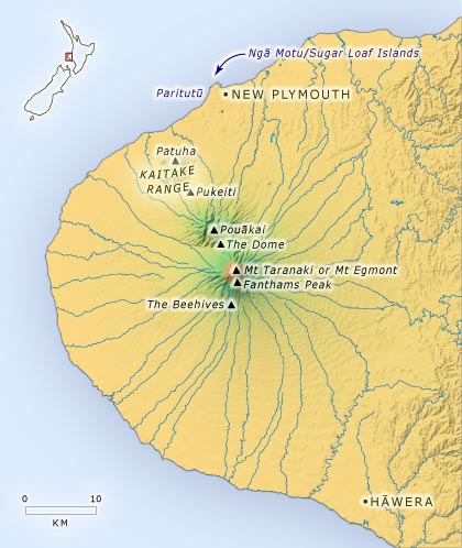
Taranaki Maunga is the latest of a sequence of volcanoes that lie on a north-west to south-east axis across Taranaki, and have formed the province through their eruptions. Once established, each volcanic centre began to erode and was eventually supplanted by a new centre, whose eruptions overtopped the landscape created by the earlier volcano.
The first volcanic centre survives as the heavily eroded Sugar Loaf Islands (Ngā Motu); nearby Paritutū was probably extruded in much the form it exists today. The next volcanic centre was the Kaitake Range, last active around 575,000 years ago. Pouākai was last active more than 200,000 years ago, whereas the last eruption of Taranaki Maunga was no more than 250 years ago. Lava deposits from Taranaki’s eruptions have mostly buried those of the earlier volcanic centres. Fanthams Peak, just south of Taranaki’s main summit, will at some point replace it.
Using this item
Te Ara - The Encyclopedia of New Zealand
This item has been provided for private study purposes (such as school projects, family and local history research) and any published reproduction (print or electronic) may infringe copyright law. It is the responsibility of the user of any material to obtain clearance from the copyright holder.