Isolation
Taranaki is isolated from the north and east by rugged hill country. In the south, gentler topographies allow easier land access. In the 2010s the tenuous nature of road and rail links to the north and east continued to concern business groups and local politicians.
Māori trails
Māori trails were foot-tracks along beaches or through the dense forests, or traversed the few canoe-navigable rivers. The best-known trail in the region was Whakaahurangi, the well-trodden highway between North and South Taranaki. It is followed closely by State Highway 3 and 3A from Hāwera to Waitara.
Tracks like Tihi-mānuka linked the area north of Taranaki with the Whanganui River. The Taumata-māhoe track leading inland from the coast at Urenui crossed the Ngāti Maru country of the upper Waitara to reach the Whanganui River. It was used by a number of early Pākehā travellers. The Kaharoa track from Pātea went north-east to join Tihi-mānuka near Tāngarākau.
Few rivers in the region were navigable. Only the Tongapōrutu, Waitara and Pātea rivers enabled boat access to the interior.
Treacherous coast
In 1903 the SS Gairloch, one of the vessels of the Northern Steamship Company, ran ashore after leaving New Plymouth port. The company operated a coastal shipping service between Onehunga, New Plymouth, Whanganui and Nelson during the late 19th and early 20th centuries. The decaying remains of the Gairloch’s bow may still be seen on the beach at Timaru Road, Ōakura, where she ran ashore.
Ports
The sea was the most important form of transport until the arrival of rail in the late 19th century. The exposed western coast had no sheltered harbours, and the mouths of all the bigger rivers had treacherous bars and tidal flows. Small ports did, however, develop at Waitara, Ōpunake and Pātea. In New Plymouth, cargo was transported by small vessels to ships waiting out at sea until the port was opened in 1881.
The man-made Port Taranaki is the only major commercial port on the western coast of New Zealand.
Roads
European settlers quickly established pack trails and then paved roads to accommodate draft animals and wheeled vehicles. Some of the earliest roads were built during the military operations of the 1860s and to enable the occupation of Parihaka in 1881. These roads facilitated the foundation of new towns, and settlement and clearance of the land for farms. Māori often viewed surveying and associated roads with great suspicion, especially during the tense confrontations over land in the 1880s.
The road north
Over the years, the hill country that reaches the coast at North Taranaki’s Mt Messenger has caused concern to travellers. In 1921 the highway was described as ‘only a summer road, long stretches of it being still un-metalled’.1 The last link in the route north was the Mōkau River bridge, which opened in 1927. Until then vehicles crossed the river on a ferry. In the 2000s, after decades of upgrading, Taranaki’s lifeline to the north was still threatened during adverse weather.
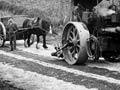
In the late 19th century networks of gravelled roads were quickly established to link dairy farms and factories. By 1900 the Taranaki ring plain had some of the best-maintained roads in the country, and many were transformed by asphalting over the next 50 years. Some roads had toll gates which helped pay for their maintenance.
The rugged terrain of the inland hills proved a challenge for road builders, settlers and travellers alike.
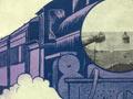
Rail
Taranaki’s first railway opened in 1875 with a line from New Plymouth to Waitara. The railway south was built quickly, reaching Stratford in 1879 and Hāwera two years later. The line north from Wellington reached Waverley in 1881, and the two lines met in 1886. The railway linked the two major areas of settlement in Taranaki, around New Plymouth and around Hāwera.
Last train from Stratford
Writer Elizabeth Smither rode on the last passenger train on the Stratford–Taumarunui line, in January 1983: ‘The names of the little towns make a lament: Toko, Douglas, grave siding of old carriages, some burnt out like Phar Lap’s ribs; Huiroa; Te Wera; Whangamomona; old rails that click and the new ones that don’t; Kohuratahi, where you could cross a field and buy ice creams thereby boosting the local trade; Tahora, Tangarakau, where a passenger sighted a wild deer; Haeo … the falling into oblivion of a town is like the falling of language.’2
A railway to connect the back country with New Plymouth and with the main trunk line was started at Stratford in 1901. Progress was slow, and the line wasn’t completed until 1932.
Falling patronage saw passenger services to Wellington end in 1977, and those to Auckland six years later.
Air
The first aircraft arrived in Taranaki in 1920. This visit turned to tragedy when New Plymouth mayor James Clarke and 25-year-old chemist’s assistant Kathleen Warnock were killed, along with pilot Richard Russell. The plane – an Avro 504K biplane of Walsh Brothers’ New Zealand Flying School – crashed while providing public flights from the New Plymouth racecourse on Armistice Day.
Civilian aero clubs were established in both New Plymouth and Hāwera by 1929. In January 1933 Charles Kingsford Smith made the fifth aerial crossing of the Tasman Sea and landed at Bell Block airfield near New Plymouth. Australian aviator Charles Ulm made three flights to the airfield over the next two years and Kingsford Smith returned in January 1934. A trans-Tasman air terminal was proposed at Bell Block, but never eventuated. One of New Zealand’s first air pageants was held for the opening of New Plymouth airport, on the airfield site, in 1936.
The Lockheed Electra Kuaka made the first commercial passenger flight to New Plymouth in 1937, beginning a regular service by Union Air Services.
During the Second World War an RNZAF training station operated from the airport. In 1966 a new airport was opened at another site in Bell Block to enable the use of faster turbo-prop planes.