

Land, climate and vegetation
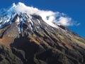
Taranaki region projects into the Tasman Sea on the west coast of New Zealand’s North Island. The region is dominated by the 2,518-metre, cone-shaped volcanic peak of Taranaki Maunga (Mt Taranaki), which is often dramatically capped with snow. The older volcanoes of Paritutū, Kaitake and Pouākai form part of the Taranaki volcanic sequence.
The peaks and their surrounding ring-plain of volcanic debris sit on mudstones and sandstones. These rocks rise to the surface east of the Taranaki Fault, forming the rugged inland hill country that meets the Whanganui River watershed in the east. To the north and south of the region are fertile coastal terraces with light, sandy soils.
Around 8 metres of rain falls annually on Taranaki Maunga, and more than 365 turbulent, fast-flowing rivers flow from the mountain in a radial pattern across the volcanic ring-plain. The rivers that rise in the eastern hill country – the Waitara and the Whenuakura – have lower gradients and are more sluggish and silt-laden.
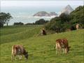
Humans have permanently changed the ecology of Taranaki. Large areas of native forest have been cleared and dozens of native plant and animal species have been eliminated or greatly reduced in numbers. The forests were replaced by pastures of ryegrass and clover for dairy farming, which became the economic basis of Taranaki.
Starring on stamps
Between 1901 and 2009 Taranaki Maunga appeared on 25 different New Zealand postage stamps. Few topographic features have achieved such coverage.
Taranaki Maunga
Taranaki Maunga is an important aspect of the identity of Taranaki people, and a crucial element in their sense of place. It is of great spiritual importance to local iwi (tribes). The mountain is responsible for the region’s moist climate and its fertile volcanic soils.
Māori arrive
Māori occupation of the area began about 1250–1300 CE. Several archaeological sites in South Taranaki – Waitore, Ōhawe and Kaūpokonui – have provided valuable information about these first settlers, their Polynesian origins and their moa-hunting lifestyle.
Taranaki Māori developed efficient horticultural systems and a distinctive wood-carving style. They built many hilltop pā near the coast, the earthworks of which remain visible. Eight iwi and their hapū (sub-tribes) identify with the Taranaki region.
In the early 19th century northern Taranaki in particular was devastated by intertribal warfare. As a result of this, many Māori migrated southward to settle on the Kāpiti Coast and at Te Whanganui-a-Tara (Wellington), where their descendants still live.
European settlement and conflict
Systematic Pākehā settlement by the Plymouth Company began in 1841. Taranaki was one of the initial six provinces established in 1853; until 1858 it was called New Plymouth. From 1860 there was more than a decade of conflict between Māori and Pākehā over land and sovereignty. From the 1870s new waves of settlers from Europe began to clear the dense ring-plain forests for dairy farms.
In 1881 the Māori settlement of Parihaka – the centre of a passive-resistance campaign against the loss of land – was occupied by government troops.
Economy
In the early 21st century the dairy industry remained the basis of the region’s economy. The oil industry’s substantial economic input from the 1960s helped to shield Taranaki’s economy from the impact of fluctuating dairy and wool prices.
The Naki
In the early 21st centuiry Taranaki was sometimes colloquially known as ‘the Naki’. When Hollywood movie The last samurai was filmed in Taranaki in 2003, locals began calling the region Nakiwood – or Tomanaki, after the film’s star, Tom Cruise. Some Māori consider the term ‘Naki’ offensive because it is an abbreviation of the name of an ancestor, Rua Taranaki.
Population
Until the mid-20th century most Taranaki residents lived in rural areas or in small service townships based around the many dairy factories. In 2013 almost three-quarters of Taranaki’s total population of 109,608 lived in towns of more than 1,000 people. 86.2% of the region’s population identified as European and 17.4% as Māori; just 1.6% identified as Pacific Islanders and 3.4% as Asian.
The largest towns in the region are New Plymouth, Hāwera and Stratford. Smaller centres include Waitara, Inglewood, Eltham, Pātea and Ōpunake.
Attitudes
A combination of regional identity, comparative isolation and innovation fostered a ‘can-do’ and ‘go-it-alone’ attitude in Taranaki’s people and local authorities, as well as a certain amount of parochialism.
The sometimes harsh struggle of farmers in the 19th and early 20th centuries meant the rest of the country sometimes saw Taranaki as isolated, rustic and impoverished.