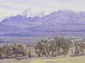

Mackenzie Basin
Large inland plain between the foothill ranges of South Canterbury and the Southern Alps and Ben Ōhau Range. It bears the name of James Mackenzie, who in 1855 was captured with sheep stolen from the Rhodes brothers’ Levels run, on the western side of Mackenzie Pass. There is a monument close to the point where Mackenzie was apprehended. One of three roads leading into the Mackenzie Country from the east crosses Mackenzie Pass.
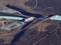
The Mackenzie Country consists mostly of extensive sheep runs, but is also the site of the Upper Waitaki power scheme, built between 1969 and 1984. The district plays an important part in the South Island’s tourist industry, offering fishing, hunting, skiing, hiking and other recreation.
In June 2012 the Mackenzie Basin and Aoraki/Mount Cook National Park became an international dark sky reserve, with the aim of promoting star-gazing and protecting astronomical research at the Mt John Observatory. At 4,367 square kilometres, Aoraki Mackenzie International Dark Sky Reserve is the largest such reserve in the world and the first in the southern hemisphere.
Ōhau
Lake Ōhau, south-west of Lake Pūkaki and Twizel, is the smallest of South Canterbury’s three inland lakes. Along the short Ōhau River are three power stations of the Upper Waitaki scheme and the dam which impounds Lake Ruataniwha. The Dobson and Hopkins rivers flow into the head of Lake Ōhau.
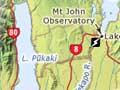
Pūkaki
Lake Pūkaki is the country’s most important hydro storage lake. The lake level was raised after a low dam and control structure were built at its outlet in the 1950s. When a new dam was built in the 1970s, the lake was raised further, to 37 metres above its original level. The initial raising of the lake submerged the renowned ‘£5 note island’ (once featured on the old £5 note, in a view towards Aoraki/Mt Cook), but the vista across the lake remains one of the best-known in New Zealand.
Tekapo
Lake Tekapo, the highest of the Mackenzie Country lakes (its maximum height is 712 metres above sea level), was first tapped for hydroelectric power in a project completed in 1951. The outflow is now diverted into a canal which flows to the Tekapo B power station on Lake Pūkaki.
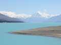
Tekapo blue
Lake Tekapo has an intense, milky, turquoise hue. This is due to a fine rock flour, ground by glacial movement and suspended in the waters. Fed by several glaciers, the inviting waters are generally too cold for swimming, except in the shallows or on the hottest days.
At Lake Tekapo’s outlet is a hotel and settlement, mainly of holiday homes. The population grew from just below 200 in 1991 to just over 350 in 2013. It is now an important centre for recreational tourism. The Church of the Good Shepherd, in a picturesque setting overlooking the lake, is one of New Zealand’s best-known buildings.
Mt John
An observatory sits on the summit of Mt John, near Lake Tekapo. It was opened in 1963 as a cooperative venture between the universities of Pennsylvania and Canterbury. Advanced astronomical research is carried out there by four New Zealand universities and Nagoya University in Japan.
Twizel
South Canterbury’s youngest town, Twizel is now the region’s sixth largest. It is 161 km north-west of Timaru and had a 2013 population of 1,137.
Saving Twizel
Once the Upper Waitaki power scheme was finished, Twizel was to be dismantled. But in 1984, town advocates persuaded the government to keep the facilities and sell the houses as holiday homes. The area is enjoying a revival, with a co-educational school for primary and secondary students, and attractions such as water sports on the artificial Lake Ruataniwha, glacier tours and skiing.
It began as a hydro construction town when the government laid out 1,200 sections and 23 km of road, on 260 hectares of former Ruataniwha Station land. Schools and shopping and community centres were built. From a population of nil in 1969, Twizel had between 5,000 and 6,000 inhabitants by 1975. The town was modelled on Mangakino in the North Island and Ōtemātātā in North Otago.
Two Thumb Range
Major range to the east of Lake Tekapo and the Godley River. It is named for the peaks that look like a pair of upturned thumbs, the higher being 2,546 metres above sea level.