Kōrero: Glaciers and glaciation

Glacial landscapes

Glacial landscapes

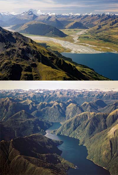
These images show two types of glacial landscape.

Top: At the head of Lake Wakatipu the twin peaks of Mt Earnslaw tower over the river flats. Huge glaciers filled these valleys until about 12,000 years ago, carving out the trough now filled by the lake. The Dart River carries a heavy load of gravel from the mountains, gradually building a delta into the lake.

Bottom: Drowned glacial valleys in Fiordland. The peaks around Dagg Sound rise only 1,100–1,200 metres above sea level, but their steep slopes make them seem much higher.

Te whakamahi i tēnei tūemi

GNS Science
Photograph by Lloyd Homer

Permission of GNS Science must be obtained before any use of this image.

Ngā whakaahua me ngā rauemi katoa o tēnei kōrero

Te tuhi tohutoro mō tēnei whārangi:

Eileen McSaveney, 'Glaciers and glaciation - Retreating ice and the glacier legacy', Te Ara - the Encyclopedia of New Zealand, http://www.TeAra.govt.nz/mi/photograph/10746/glacial-landscapes (accessed 25 April 2024)

He kōrero nā Eileen McSaveney, i tāngia i te 24 Sep 2007, updated 1 Apr 2021