In the North Island, ranges with summits of 1,500 metres or higher cover about 20% of the total land area. Elsewhere are ranges of lower altitude or steep, dissected hill country.
The highest peaks: volcanoes
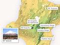
The North Island has only three mountains over 2,000 metres, all of which are volcanoes:
- Mt Ruapehu (2,797 metres), at the centre of the island – the highest peak and the only one with glaciers
- The classic volcanic cone of Mt Ngāuruhoe (2,287 metres), just north of Mt Ruapehu
- Mt Taranaki/Mt Egmont (2,518 metres), the isolated sentinel in the west, and another elegant cone.
Eruptions
There have been many minor ash eruptions from both Mt Ruapehu and Mt Ngāuruhoe over the past 150 years. More significant eruptions occur from time to time. The most recent were in 1974–75 (Mt Ngāuruhoe) and 1995–96 (Mt Ruapehu). Mt Taranaki (Mt Egmont) has not erupted in the past 250 years.
1886 Tarawera eruption
The most explosive and destructive eruption in the last 200 years was on Mt Tarawera (1,111 metres) near Rotorua in 1886. Between 108 and 120 people died as a result. The country’s most famous 19th-century tourist attraction – the pink and white silica terraces bordering Lake Rotomahana – was totally destroyed.
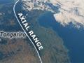
Axial ranges
East of the volcanoes lies an unbroken mountain chain: the Tararua, Ruahine, Kaweka, Kaimanawa, and Raukūmara ranges. They extend from the southern end of the North Island up to East Cape, along the same south-west to north-east axis as the Southern Alps and Kaikōura Ranges.
These ranges are significantly lower than the volcanic mountains. The principal summits are all between 1,500 and 1,730 metres high.