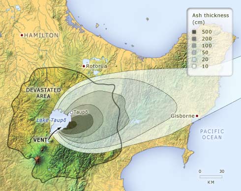
The Taupō eruption, about 232 CE, affected a large part of the central North Island. The land within about 80 kilometres of Lake Taupō was completely devastated by a ground-hugging pyroclastic flow near the end of the eruption. The thickest ash fall was deeper than 500 centimetres. A much wider area got at least a thin dusting of ash.
Te whakamahi i tēnei tūemi
Te Ara - The Encyclopedia of New Zealand
This item has been provided for private study purposes (such as school projects, family and local history research) and any published reproduction (print or electronic) may infringe copyright law. It is the responsibility of the user of any material to obtain clearance from the copyright holder.
Source: GNS Science


Tāpiritia te tākupu hou