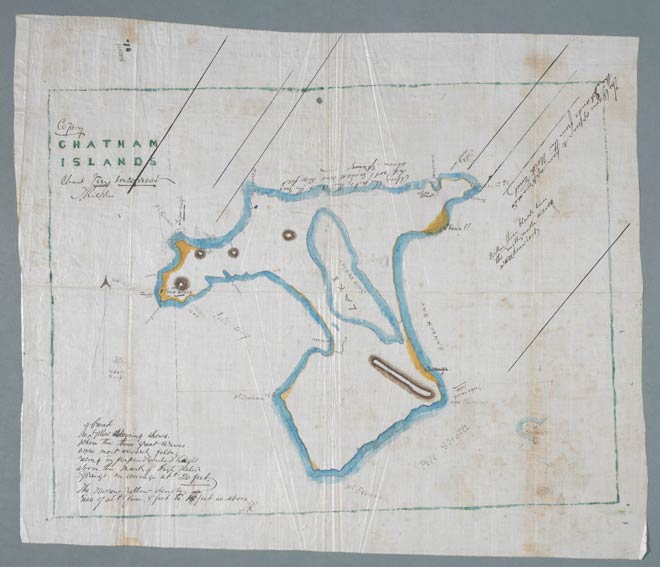
A tsunami originating off the coast of Chile in 1868 struck sections of the Chatham Island coast over 15 hours later (at about 1.00 a.m. on 15 August 1868). Local runholder and trader Thomas Ritchie sent a letter to Charles Heaphy, then a member of the House of Representatives, describing the effect of the tsunami. He enclosed this map showing the areas that were inundated.
A note on the map says: ‘The broad yellow colouring shows where the three great waves were most severely felt, rising in perpendicular height above the mark of high water springs on average about 20 feet. The narrow yellow denotes a rise of about 8–15 feet as above.’
The Weekly Press of 28 August 1868 reported the devastation: ‘The settlement of Tupunga, on the north side of the Island, felt the greatest force. It is entirely destroyed; no mark being left to tell where it stood. … The sea went inland four miles. A Maori trying to save a boat was carried out to sea by the drawback and drowned. … The settlement of Waitangi has suffered great losses. The houses were lifted from the ground and carried out to sea. … The force of water at Tupunga was so great that drays were smashed and stones half a ton weight were carried a considerable distance.’ (p. 15)
Te whakamahi i tēnei tūemi
Museum of New Zealand Te Papa Tongarewa
Reference: MU243, Box 1, Folder 4
Permission of the Museum of New Zealand Te Papa Tongarewa must be obtained before any re-use of this image.