
Earliest magnetic measurements
The earliest magnetic measurements in New Zealand were made at Ship Cove, Marlborough Sounds, during James Cook’s first visit in 1770. Cook determined the magnetic declination, but at that time the technology was not available for measuring the strength of a magnetic field.
Between 1848 and 1854 the British Admiralty conducted an extensive survey of New Zealand, using the ships Acheron and Pandora. This included measurements of the magnetic declination in many harbours to detect any local magnetic features.
National magnetic surveys
A more extensive magnetic survey was conducted in the first decade of the 20th century to identify any magnetically disturbed regions. Another complete magnetic survey of New Zealand was undertaken from 1941 to 1948.
Magnetic observatories provide records of events like magnetic storms for scientific analysis. They also provide baseline values for other magnetic measurements. In 1901 continuous measurements started at a Magnetic Observatory located in the Botanic Gardens, Christchurch, and one of the original buildings still survives. The observatory was shifted to Amberley, 50 kilometres north of Christchurch, in 1928 because of interference from the DC supply to the electric trams. In 1978 it was relocated at the current Eyrewell site, because of increasing development at Amberley.
New Zealand has been responsible for continuous magnetic measurements at Scott Base in the Antarctic, since the base was built during the 1957–58 International Geophysical Year. Both the Eyrewell and Scott Base stations (and a station at Apia in Samoa, now operated by the Samoan government) provide near real-time magnetic data to International Data Centres as part of the global magnetic observatory network INTERMAGNET.
GNS Science now has responsibility for maintaining the observatories and undertaking regular magnetic measurements in the New Zealand region.
Local variation in magnetic rocks
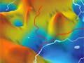
In some areas, magnetised rocks alter the magnetic field – for example, the magnetised black sand along the west coast of the North Island, or magnetised volcanic rocks. Aeromagnetic surveying can identify magnetic rocks, and is widely used in mineral exploration. Most of New Zealand is covered by reconnaissance aeromagnetic maps at a 1:250,000 scale, and maps of the oceans are also available.
Because rocks lose their magnetism as they are heated, magnetic techniques are also used to locate thermal regions, which have lower than normal magnetisation.
Stokes Magnetic Anomaly
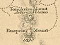
A linear belt of deep-seated magnetic anomalies that extends along the western side of New Zealand has been named the Stokes Magnetic Anomaly after John Lort Stokes, the captain of HMS Acheron, who first recognised unusual magnetic features near Nelson during surveys in 1849–51. They are thought to be caused by a belt of volcanic and intrusive rocks, and are one of the features that has been offset about 480 kilometres along the Alpine Fault.