Karren
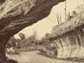
Before rainwater drains underground, it flows across and corrodes rocky outcrops on the surface. Outcrops form into sculptures of vertically fluted rock and widely opened joints, collectively known as karren. These are particularly common above the treeline, where soil and plants are thin or absent. One of the best places to see these landforms is from the main road on Tākaka Hill, between Nelson and Golden Bay. Karren also develop beneath soil and vegetation, where they are smoother.
In some areas, bedrock has been scoured by glaciers and stripped of loose debris, leaving a flat surface. Joints have opened up and been cut downwards by the dissolving force of water. The resulting landforms are called limestone pavements. Large areas of these, especially above the treeline, are called karrenfields. These are common on Mt Owen and Mt Arthur. Mt Owen’s karrenfields featured in the film trilogy The lord of the rings.
Subterranean tourism
The Waitomo Caves are New Zealand’s most popular tourist caves. Wai means water in Māori, and tomo is a hole in the ground – a word that cavers have adopted for potholes or shafts. In 1887, Tāne Tinorau and Fred Mace floated on a raft of flax flower stalks into the Waitomo glow-worm cave. The caves soon became popular with tourists, who were guided by local Māori. In 1905, the government’s Tourist Department took over the caves’ management.
Dolines
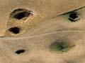
A karst landscape’s surface is often pocked with closed depressions, especially the bowl- or saucer-shaped hollows called dolines. These are usually up to 100 metres in diameter and tens of metres deep. When dolines take up all the available space, the surface looks like an enormous egg tray, and is known as polygonal karst. At Waitomo, the polygonal karst has 55 hollows per square kilometre.
Sometimes the ground over a cave collapses, forming a crater at the surface. These are known as collapse dolines. In New Zealand they are sometimes called tomos, although this term also applies to collapse pits in soil.
Disappearing streams and lakes
Streams that flow from other rocks onto neighbouring limestones often dissolve the limestone and sink underground. Their valley may finish abruptly, sometimes against quite a steep slope. These are known as blind valleys.
Lake Disappear, near Raglan in the western North Island, is a large enclosed hollow (polje) drained by an underground stream. The lake fills after heavy rain, when the flow of incoming water is too great for the stream-sink to drain. In drier weather, it empties and disappears.