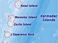

The Kermadec Islands are a group of small volcanic islands, 800–1,000 kilometres north-east of the North Island. The largest, Raoul Island, is 29 square kilometres in area. The other islands are small and collectively cover less than 4 square kilometres. The islands are strategically important, as they define the northern extent of New Zealand’s Exclusive Economic Zone (EEZ) and Extended Continental Shelf (ECS).
Comparing islands
At 29 square kilometres Raoul Island is larger than Kāpiti (19.6 sq km), half as big as Manhattan (59 sq km) and three-eighths the size of Hong Kong island (80 sq km).
All the Kermadec Islands are part of a specially designated nature reserve, so a permit from the Department of Conservation is required to set foot on land. The surrounding seas are also protected by the Kermadec Islands Marine Reserve, which extends for 12 nautical miles from the coastline of each island. It covers an area of 7,450 sq km, the coastal parts of which are rich in marine life, despite a lack of nutrients in the surrounding ocean. The surprising amount of sea life may be due to tidal movements that disturb water to a great depth, bringing nutrients to the surface.
The islands are uninhabited, except for Raoul, where a field station is maintained by the Department of Conservation. Staff and volunteers collect meteorological and seismic information, control weeds and supervise the marine and nature reserves.
Climate
With a mild, subtropical climate, the islands have average temperatures ranging from 16.0°C (August) to 22.4°C (February). Total annual rainfall is approximately 1,500 mm, spread through the year, with occasional cyclones.
Being subtropical rather than tropical, the Kermadec Islands are close to the southern limit for most coral species. There are no coral reefs, and only individual corals are found on the sea floor, mainly in shallow clear water.
Lucky escape
In 1954 the British government requested permission to test a hydrogen bomb in the Kermadec Islands. Although there had been eruptions in 1814 and 1870, no one recognised that Raoul was an active volcano. Indeed, the central flat area surrounded by steep cliffs (now recognised as the Raoul caldera) seemed an excellent testing spot. Fortunately the request was declined by the New Zealand government – for political rather than scientific reasons.
Volcanoes on the Kermadec ridge
The rocks of the Kermadecs are no more than 1 million years old, and some of the youngest have been erupted within the last few hundred years. The islands are the only part above sea level of a chain of huge submarine volcanoes. Mapping of the sea floor since 1998 has shown that a north-east-trending line of 40 volcanoes (Kermadec ridge) extends between New Zealand and Tonga. These volcanoes mark the collision zone between two tectonic plates, where the Pacific plate is being subducted (pushed down) beneath the Australian plate, causing melting deep in the crust. Large earthquakes occur on or close to the plate boundary.
Some of the volcanoes are still active, and submarine eruptions are a hazard because of the ejection of ash clouds. Both volcanic eruptions and earthquakes on the Kermadec ridge have the potential to generate tsunamis. At least three earthquakes of more than magnitude 7 took place along the Kermadec ridge in the second half of 2011 alone.