

A flood-prone land
Early European settlers in New Zealand commonly chose to live next to rivers or lakes, as these were sources of fresh water and the adjacent plains usually had fertile soil. Coastal areas were also attractive sites. Consequently, about two-thirds of New Zealanders now live in areas that are naturally prone to flooding. Nearly 70% of towns and cities with populations of over 20,000 have river flood problems.
Human activity has also increased the likelihood of flooding. Large areas of native forest were cleared by both Māori and Europeans, leading to more rapid run-off of rain into stream networks, and to erosion that raised the levels of river beds.
In urban areas, buildings, footpaths and roads have replaced ground that would normally soak up falling rain. This leads to surface flooding during heavy rain, and increases the run-off into storm drains, causing higher water levels in local streams.
Wild water
At Avonhead lived one Mister Bray,
Who every morning used to say
‘I should not be much surprised today
If Christchurch city were swept away
By the rushing, crushing, flushing, gushing Waimakariri River.’
This 1860 poem by Canterbury politician and poet Crosbie Ward refers to the engineer William Bray, who predicted that the Waimakariri River would break its banks and run through Christchurch. His prediction came true in February 1868, when the Waimakariri overflowed into the Avon River and other old stream channels, flooding parts of the city.
Legislating flood control
Early attempts at controlling rivers were piecemeal – to protect a homestead, individuals would build stopbanks that sometimes deflected river flow onto neighbouring properties. The River Boards Act 1884 set up a national network of river management. But a single river was often controlled by severaldifferent boards.
In April 1938, a flood in Hawke’s Bay left the lower Esk Valley buried under metres of silt. The disaster spurred an effort to control floods, resulting in the Soil Conservation and Rivers Control Act 1941. This pioneering legislation, as well as the later Water and Soil Conservation Act of 1967, authorised catchment boards to deal with complete river systems – both in carrying out river control works and in controlling erosion in their catchments.
In 1991, the Resource Management Act turned over flood control to regional and territorial authorities as part of their obligation to avoid or mitigate natural hazards.
Controlling the rivers
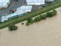
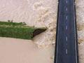
A number of techniques are used in New Zealand to control rivers. Thousands of kilometres of stopbanks have been built to keep high river levels within the channels; this has allowed dense settlement of areas such as Christchurch, Hutt Valley and the Heretaunga Plains. Christchurch, for example, is situated mainly on a flood plain. It occupies part of the huge alluvial fan of the Waimakariri River, which has frequently changed course, sometimes entering the sea as far south as Lake Ellesmere. Stopbanks now keep the Waimakariri in one place along the northern edge of the fan.
Stopbanks can be very cost-effective. It has been estimated that spending $10 million on a stopbank on the lower Buller River would have prevented $100 million of damage caused when the river inundated the south-eastern part of Westport in July 2021.
Stopbanks, however, may also cause problems. Near Franz Josef, stopbanks built to protect the township narrowed the bed of the Waiho River. The riverbed built up so much that in 2011 the State Highway 6 bridge had to be raised to stay clear of the river. In 2016, the river breached the stopbank, flooding two hotels and a campground. The Waiho bridge was washed away in a flood in March 2019.
Solution – or problem?
In 1877, Hawke’s Bay County began to plant willows along river margins to help prevent bank erosion. Less than 20 years later, in 1894, the county set up a sub-committee to deal with ‘the willow nuisance’. The trees, which impeded the flow of rivers during floods, continued to be a worry for the next half-century.
One method of preventing rivers overflowing their stopbanks is to lower the river bed by removing gravel. Speeding the passage of flood waters through an area can involve straightening river channels and removing obstructions such as vegetation. Another method of flood control is damming or diverting flood water until river levels drop. To protect communities downstream, some river stopbanks have floodgates that can be opened to deliberately spill flood water onto less densely settled farmland. The Moutoa Sluice Gates, for example, divert excess water from the Manawatu River into a floodway that rejoins the river 10 kilometres downstream.
New Zealand’s large dams were built for power generation, irrigation and water supply, but they have at times buffered major floods.
False sense of security
A common expression in discussions about floods is that a particular event is a ‘one-in-100-year flood’. Some understand this to mean that this event could only happen once every 100 years, which may give them a false sense of security. However, what the phrase really means is that there is a 1% chance of it occurring in a given year, and if it did happen, the probability of it happening again the following year (or in any subsequent year) would still be 1%. As climate change continues to affect New Zealand, ‘one-in-100-year’ events are likely to increase in frequency and intensity.
One method of preventing rivers overflowing their stopbanks is to lower the riverbed by removing gravel. Speeding the passage of flood waters through an area can involve straightening river channels and removing obstructions such as vegetation. Another method of flood control is damming or diverting flood water until river levels drop. To protect communities downstream, some river stopbanks have floodgates that can be opened to deliberately spill flood water onto less densely settled farmland. The Moutoa Sluice Gates, for example, divert excess water from the Manawatū River into a floodway that rejoins the river 10 kilometres downstream.
New Zealand’s large dams were built for power generation, irrigation and water supply, but they have at times buffered major floods.
While heavy engineering work such as stopbanks remain important, other solutions have been implemented. Councils can give rivers and streams in urban landscapes more space to take their natural course, be more vigilant about keeping rivers, streams and stormwater drains clear, and build and maintain wetland areas, which can better absorb rainfall.