
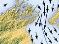
Much of New Zealand lies in or near the stormy latitudes known as the roaring forties, between 40° and 50° south. The country’s elongated shape and north–south orientation means that it is buffeted by prevailing westerly storms, ocean swells and currents. In addition, it lies astride one of the world’s major plate boundaries, where the seabed is ruptured by faults.
New Zealand’s dynamic sea floor can be both a challenge and a nightmare for offshore engineers. Marine geologists can determine the risks posed by natural processes to structures built on the seabed.
Cook Strait
Some of New Zealand’s largest offshore engineering projects have been around Cook Strait, where storms and strong currents are funnelled between the North and South islands. They scour the seabed, or stir it into abrasive sand or gravel waves.
Submarine avalanches
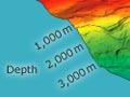
In deeper water off the continental slope the effects of storms, waves and tides may be less important, but underwater avalanches and landslides are hazardous to the submarine communication cables that form vital communication links between continents.