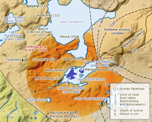
This map shows the main area affected by the Tarawera eruption, and gives an estimate of the number of deaths at different localities.
The northern end of the Tarawera rift sent up a column of scoria and ash, similar to that of Vesuvius in 79 AD. The eruption at the southern end of Tarawera was phreatomagmatic – the result of contact between hot magma and water – and covered the country with a hot, fast-moving blast of fragmented rock that destroyed everything in its path.
Te whakamahi i tēnei tūemi
Te Ara - The Encyclopedia of New Zealand
Source: David J. Lowe, University of Waikato
This item has been provided for private study purposes (such as school projects, family and local history research) and any published reproduction (print or electronic) may infringe copyright law. It is the responsibility of the user of any material to obtain clearance from the copyright holder.
Comments
08 May 2016
18 March 2012