
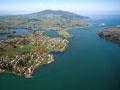
Raglan Harbour (Whāingaroa)
Harbour 50 km south of Port Waikato, 13 km long and 2–3 km wide, with two arms fed by the Waingaro and Waitetuna rivers. Whāingaroa means ‘the long pursuit’, referring to the Tainui waka’s search for its destination. From the late 1700s the Ngāti Māhanga tribe occupied surrounding land.
In the 1820s flax trader John Rodolphus Kent called at the harbour, and in the 1830s it was surveyed by Captain Thomas Wing. Ngāti Māhanga chief Wiremu Nēra Te Awa-i-taia, a Christian convert, supported the establishment of a Wesleyan mission station at Te Horea on the northern shore in 1835–36. It shifted to Nihi Nihi, near present-day Raglan, in 1839.
There was a port from the 1850s, but by the 1970s only cement was landed, and it closed in 1981.
A rocky road
In 1879 a road, known as the Old Mountain Road, was formed between Raglan and Hamilton. Very winding, with steep gradients, it proved unsuitable for motor traffic so a deviation was constructed from Whatawhata to north of Waitetuna between 1907 and 1913. The road was not properly upgraded until the late 1950s and became a state highway in 1961.
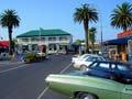
Raglan
Town on the southern shore of Raglan Harbour (Whāingaroa), with a 2013 population of 2,736. The settlement dates from 1854, when the government began buying land in the area. First called Whāingaroa village, in 1858 it was renamed after Lord Raglan, British commander in the Crimean War. During the Waikato war Te Awa-i-taia protected the settlement, and it was garrisoned by troops. Raglan relied on shipping until adequate roads were developed.
Dairy farming started nearby in the late 1800s, but from the 1930s many dairy units changed to sheep farming, which was more suited to the hilly terrain. Near Raglan, the farming settlements of Te Hutewai, Te Mata, Kauroa and Te Uku emerged.
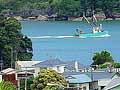
Raglan supports a commercial fishing industry. A seaside resort for Hamiltonians, it has also been a surfing town since the 1960s. As road improvements have allowed people to live there and commute to Hamilton for work, property prices have boomed.
Te Ākau
Farming district north of Raglan Harbour (Whāingaroa). West Waikato lands were confiscated after the Waikato war, but a stretch between the harbour and Port Waikato was returned to Māori who did not fight. The Te Ākau block of over 36,000 hectares was leased by South Island runholders H. C. Young from 1868 and John Studholme from 1874. The station homestead at Te Horea was linked with Raglan by ferry. The station gained a freehold title and was subdivided around 1911.
Waingaro
Locality 30 km north-east of Raglan. In 1885 its thermal springs, long known to Māori, were discovered by Pākehā. A hotel and bathing pools were constructed and the track from Huntly and Ngāruawāhia was upgraded to a road. Travellers arriving by coach went by launch down the Waingaro River and across the harbour to Raglan. People and goods from Raglan travelled the other way. The hotel still stands, and the pools remain a favourite destination for locals.
Beaches south of Raglan
Ngarunui Beach is reached by a track through the picturesque Bryant Memorial Scenic Reserve. Further on, Manu Bay and Whale Bay are among New Zealand’s premier surf locations, with unusual left-hand surf breaks. Beyond Mt Karioi is windswept Ruapuke Beach, which is unsafe for swimming.
Gardens in a gorge
The dramatic Te Toto Gorge begins as a deep-cut stream on the slopes of Mt Karioi, winding down into a semi-circular basin with 60 m basalt cliffs. In the 17th and 18th centuries the area was gardened by Māori, and there are remnants of stone rows, storage pits, terraces and two small pā.
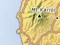
Mt Karioi
Volcanic cone (756 m) south-west of Raglan Harbour (Whāingaroa). The mountain’s vegetation has been sculpted by westerly winds. Sailing along the coast, explorers Abel Tasman and James Cook observed Mt Karioi, and Cook named it Woody Head.
Aotea Harbour
Inlet 27 km south of Raglan Harbour (Whāingaroa), an important habitat for sea and shore birds. It was the landing place of the Aotea waka, which brought the ancestors of the Ngā Rauru and Ngāti Ruanui tribes to New Zealand. When they discovered Tainui people in occupation, they travelled south to Taranaki. Ngāti Te Wehi is the local Tainui tribe.
Near Raoraokauere, a Wesleyan mission that operated from 1840 until 1856 is commemorated by a cairn of bricks from the station’s chimney. Aotea Harbour was not heavily settled by Pākehā because of its dangerous bar.
The Aotea Scientific Reserve preserves archaeological sites, including evidence of intensive Māori gardening.
Bridal Veil Falls
Waterfall 4 km south of Te Mata. Its Māori name, Wairēinga, means ‘water of the underworld’. The Pakoka River spills 55 metres over a lip of basalt into a natural amphitheatre. Surrounding forest includes orchids and five species of rātā.