


Matamata
Town 62 km east of Hamilton, with a 2013 population of 7,089. Some houses were built near the Matamata railway station, completed in 1885, but settlement did not really grow until Josiah Clifton Firth’s huge estate passed to the Crown and was subdivided in 1904. Matamata became a borough in 1935. At the heart of a rich dairying area, Matamata developed as a rural service centre. Horticultural blocks and horse studs were established nearby. Engineering and construction businesses were also set up from the 1920s. Access to ports via the Kaimai railway tunnel has helped Matamata prosper.
Hobbiton
After part of the Lord of therings trilogy was filmed on a farm near Matamata in the 1990s, Matamata began billing itself as ‘Hobbiton’ to attract tourists wanting to visit the former film set. Interest was revived in 2011 when the set was reconstructed for the filming of Thehobbit.
A concrete tower built by Firth in 1882 as a defensive work in case of Māori attack is now a central feature of the Firth Tower Museum on the outskirts of Matamata.
Waharoa
Township 7 km north-west of Matamata, with a 2013 population of 465. A few kilometres north of present day Waharoa, on a ridge above the Waitoa River, Ngāti Hauā chief Te Waharoa established a pā in 1830. An Anglican mission started nearby in 1835, but was abandoned in 1836 when war broke out between Te Waharoa and neighbouring tribes. A Catholic mission station opened in 1841, but three years later shifted to Rangiaowhia, near Te Awamutu.
Peria
Ngāti Hauā chief Wiremu Tāmihana Tarapīpipi, sometimes called ‘the Kingmaker’ because of his central role in the Kīngitanga, was a devout Christian. In the 1840s he established a village north-west of Matamata which he called Peria, after Berea in the New Testament. At this village, of which no trace remains, he and his followers had a farm, flour mill, boarding school, post office, church and meeting house.
In 1865 Firth leased land in the area from Te Waharoa’s son, Wiremu Tāmihana Tarapīpipi, and by 1887 he owned more than 56,000 acres (22,660 hectares) outright. Firth opened the Waharoa Dairy Factory in 1886, and a canning factory the next year. The township of Waharoa developed around these industries. In the early 2000s two cheese factories opened at Waharoa: the Kaimai Cheese Company, a small, speciality cheese factory; and the much larger Open Country Dairy Company.
Kaimai railway tunnel western portal
Entrance to the railway tunnel through the Kaimai Range. At 8.85 kilometres, it is the longest rail tunnel in New Zealand. It was built primarily to shorten the rail route between the timber towns of south Waikato and the port at Mt Maunganui. Construction began in late 1965 but was plagued by technical difficulties because of the very hard volcanic rock. Four men died in a cave-in near the western portal on 24 February 1970. Work was finally completed in 1978.
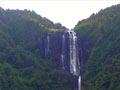
Wairere Falls
Waterfalls 14 km north-east of Matamata, on the foothills of the Kaimai Range. The falls, which are visible from much of the Waihou–Piako basin, mark the western end of the Ōkauia fault line. The Wairere Stream descends through the surrounding forest, with two drops of 91 and 60 m. A steep track with sets of steps leads to a lookout at the top of the falls.
The Wairere track – which ran through forested ranges between Te Puna in the Bay of Plenty and the Waikato region, emerging at the Wairere Falls – was a link over the Kaimai Range for centuries. It was used first by Māori, and later by European traders, missionaries and armed forces. By the 2000s it led only part of the way across the range, but connected with other tracks that came out on the Bay of Plenty side.
Ōkauia
Farming locality 8 km north-east of Matamata. Ōkauia is at the centre of an area that has long been occupied by Ngāti Raukawa. The Ōkauia thermal pools were developed as a tourist attraction in the early 1900s, and in the 2010s were known as Opal Hot Springs.
Hinuera cliffs
Natural feature beside the road between Lake Karāpiro and the settlements of Piarere and Hinuera. The cliffs mark the course of the Waikato River 20,000 years ago, before it began to flow to the west. The ignimbrite of which they are formed is yellow-cream to pale brown, and contains fragments of pumice. Mined since the 1950s and marketed as Hinuera stone, it is a sought-after building material.