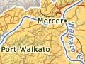


At 425 km, the Waikato is the longest river in New Zealand. It begins on the slopes of Mt Ruapehu, draining into Lake Taupō and exiting at the north-east. After flowing through a string of hydroelectric dams and passing through lowlands between Cambridge and Mercer, it turns westward, entering the Tasman Sea at Waikato Heads. The Waipā River, which rises in the King Country, meets the Waikato River at Ngāruawāhia.
Significance to Māori
The Waikato River provided physical and spiritual sustenance for Māori living along its banks. The spirits of ancestors were said to mingle with its waters, which were used in rituals. Orators addressed it as having a life-force of its own. It was a source of food, including eels, mullet, smelt and whitebait, and plants like watercress. It was an important waka (canoe) route, especially from the mid-1800s when Māori began taking their farm produce to distant markets. In 1859 scientist Ferdinand Hochstetter called it ‘the Mississippi of the Maoris’. 1
Waikato of a hundred chiefs
A well-known saying about the Waikato River uses taniwha (mythical water spirits) as a metaphor for chiefs: ‘Waikato taniwha rau, He piko he taniwha, he piko he taniwha’.2 (Waikato of a hundred taniwha, on every bend a taniwha). This saying relates the power and prestige of the Waikato tribes to that of the river.
In 1993 the Waitangi Tribunal acknowledged that the river was a taonga (treasure) of the tribes of Tainui and Ngāti Tūwharetoa. Ngāti Tūwharetoa has interests in the ‘Taupō waters’, including Lake Taupō and the Waikato River downstream of the lake as far as Huka Falls, while Tainui tribes claim mana (authority) over the rest of the river.
Importance to Europeans
When British troops invaded Waikato in 1863–64, gunboats took supplies, men and equipment upstream, and bombarded Māori pā that blocked the way.
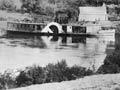
After militia towns were established, the river became a lifeline for Pākehā settlers. Boats brought supplies up the Waikato as far as Cambridge, and also travelled the Waipā River to Alexandra (now Pirongia). Later, farm produce and coal were taken to markets via the river, and until the mid-1900s it was used to shift road metal and sand.
Floods
Farming adversely affected the river. Swamp drainage reduced ponding areas for flood waters, and removal of vegetation increased runoff into the river. The Waikato–Waipā drainage system became overloaded and there were floods in the lower reaches from the late 19th century. The Waikato Valley Authority, set up in 1956 to tackle the problem, constructed flood-control works during the 1960s. Revegetation and creation of reserves in the upper reaches helped reduce erosion and silting of the river from adjacent pumice land.
Hydro schemes
The construction of hydroelectric power stations dramatically changed the river’s flow. By 1970 eight dams formed a staircase profile between Āratiatia and Karāpiro. They were Arapuni (1929), Karāpiro (1947), two linked dams at Maraetai (1953 and 1970), Whakamaru (1956), Atiamuri (1958), Waipapa (1961), Ōhakuri (1961) and Aratiatia (1964). Some rapids and geothermal features were flooded when the river was dammed, and artificial lakes were created. The Tongariro power scheme, which diverted waters from the Tongariro, Rangitīkei, Moawhango, Whakapapa and Whanganui river catchments to power hydro stations south of Lake Taupō, increased the volume of water in the Waikato River.
Pollution
Stormwater, phosphate runoff and animal waste are discharged into the river from a catchment area of around 8,800 sq km. The river flow of 233 cubic metres a second dilutes this. However, pollution has hastened the decline in native fish numbers over the past 100 years, and one species, the grayling, has become extinct. Most aquatic plants are now introduced species. The river’s health is of concern to Māori and conservationists, and also to recreational users such as swimmers, kayakers and waterskiers.
Tainui settlement
In 2008 Waikato-Tainui tribes signed an agreement with government to protect the Waikato River for future generations, and this was made law under the Waikato-Tainui Raupatu Claims (Waikato River) Settlement Act 2010. Waikato-Tainui has kaitiakitanga (guardianship) of the river and works in partnership with government and local-government agencies such as the Waikato Regional Council to manage it.