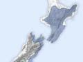
Waenganui location
Waenganui (the middle) is a name applied to central parts of the country by geographers in the mid-20th century. In the North Island the Waenganui region comprised the interior of the North Island below Auckland, and the coast south of Whanganui and Hawke’s Bay. In the South Island, it covered the coast from Cape Farewell to Banks Peninsula. Waenganui had around 15% of the Māori population. Limited horticulture of Polynesian cultigens was possible in some parts, though taro would not grow at all.
Horticulture
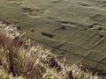
Horticulture was not possible in the central North Island, but crops were grown elsewhere, especially on the Wairarapa coast. Soils were modified and stone walls were made. Forest was cleared so land could be cultivated.
In the South Island evidence of horticulture is found along the strip from Cape Farewell to Banks Peninsula, including stone structures, modified soils and borrow pits (holes where stone had been carried away).
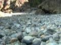
Stone resources
Limestone and greywacke were the most significant stone resources in the north of the region. High-quality argillite was found on Rangitoto ki te Tonga (D’Urville Island) and was traded through the North and South islands. Limestone flint was also present.
Stone was traded in from other areas. Obsidian from Tūhua (Mayor Island), Coromandel Peninsula, Northland and the central North Island, and argillite from Rangitoto (D’Urville Island) have been found at an archaeological site in Wairarapa.
Bush clearance
In the northern part of the region large areas of bush around Lake Taupō and the Rotorua lakes were destroyed by the eruption of Kaharoa, or burnt off for horticulture. Further south, most of the Wairarapa was cleared of bush. In the South Island, the forest was cleared in Whakatū (Nelson), and from Wairau down to Akaroa on Banks Peninsula.
Moa and seals
Prior to the extinction of moa and the depletion of seal colonies, moa and seal were significant foods. Evidence of sealing, and medium-sized moa hunting and butchering sites, is found along the Wellington coast and in the South Island, including one at Whakatū. Particularly large moa hunting and butchering sites have been found at Banks Peninsula and Wairau.