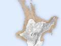
Iwitini location
Up to 80% of New Zealand’s Māori population lived in the region mid-20th-century geographers named Iwitini (many people), the northern North Island and the island’s coastal regions as far south as Whanganui on the western side and southern Hawke’s Bay on the east.
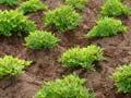
Horticulture
Polynesian horticulture was most successful in this area. Polynesian cultigens were kūmara, taro, uwhi (yam), hue (bottle gourd), aute (paper mulberry) and tī pore (cabbage tree). The kūmara grew best in this region, and was the principal food crop cultivated. Except in some small areas with ideal microclimates, taro would not grow outside of the region.
The importance of horticulture to Māori is illustrated by the fact that this region had 98% of all pā, which were often erected to protect fertile lands and crops.
Matariki
The kūmara harvest was a time for feasting. Kūmara damaged when they were dug up were eaten, and the birds in the forest were fat. This coincided with the rise of Matariki in the dawn sky and the Māori new year. People had a saying ‘Matariki ahunga nui’ – Matariki provider of plentiful food.
Bush clearance
Polynesian horticulture went hand in hand with bush-burning. Large tracts of land in the region, particularly coastal land, was cleared of forest. Coastal strips were cleared from Whanganui through to Taranaki, in Hawke's Bay and on the East Coast. Much of coastal Bay of Plenty, the Coromandel and Auckland had significant bush clearance, together with large areas of Northland.
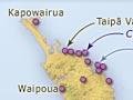
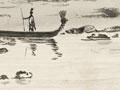
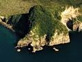
Resources from the sea
Most of the population within the region lived on or near the coast. There were numerous harbours and estuaries rich in fish and shellfish, as well as fertile land for horticulture, and access to the sea for transport.
Land around Te Mānuka (Manukau Harbour) was highly sought after. The large harbour had portages to the Pacific and the Waikato River and was valued as a fishing ground for snapper, flounder and mullet, and for shellfish. Many kāinga (villages) were found on its shores and pā were erected on most of the volcanic cones nearby.
The Whanganui-a-Orotu was also a valued harbour in Hawke's Bay. Its abundance of resources meant the large population, possibly numbering in the thousands, lived near the harbour.
Stone resources
Stone resources were heavily traded throughout the country and land near major stone sources was valued.
The Coromandel provided good access to obsidian, basalt and chert. Obsidian was also found on nearby Aotea (Great Barrier Island), in the far north, and on Tūhua (Mayor Island) in the Bay of Plenty. Chert was also found on the East Coast. Other stone resources such as pounamu (greenstone) were only available through trading.
Forest resources
Kauri for large waka (canoes) was available within the region, though its southern limits were Kāwhia in the west to Tauranga in the east. Tōtara was also used for building.