
In the winter of 1874, scientists on the Challenger expedition threw dredges over the side of the ship when it visited New Zealand waters, probing the unseen depths of an ocean they had little understanding of. They were constrained by a cursory knowledge of the major ocean currents, with only the most rudimentary instruments at their disposal.
Satellites
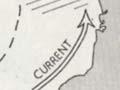
Today’s oceanographers use satellites to map the ocean surface. Space-borne sensors can determine surface temperatures, the height of the ocean surface (which changes with the currents and temperature), the size and direction of waves, wind strength, and the amount of chlorophyll present.
Ship-based exploration
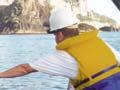
But even the most sophisticated satellite technology cannot provide analyses of the ocean beyond a few centimetres deeper than the surface. Research voyages remain the best way to explore the depths. In New Zealand these trips typically last a month or more, during which time scientists lower sophisticated gear over the side of their vessel, sometimes immediately pulling it back on board, at other times leaving it moored for a year or more to record changes in ocean properties. Valuable data is archived and synthesised to build a picture of how ocean environments behave.
Smart floats
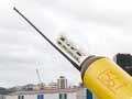
Ships are expensive and cannot be everywhere. An ambitious approach to mapping the ocean interior uses smart floats – floats with computers in them that adjust their buoyancy to rise and fall in the top 2 kilometres of the ocean and record position and water properties as they go. When a float is at the surface it transmits its data to a base on land. There are more than 1,000 floats drifting through the world’s oceans, including the Pacific Ocean and Tasman Sea.
Computer modelling
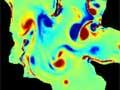
Computer models can be used to predict ocean behaviour in places and times for which there is no data. For example, they can forecast how ocean currents might behave in future climates. Most models simulate the ocean as a grid of vertical and horizontal boxes, and determine how water moves from one box to the next.
Simulations can cover all the world's oceans (global models), or smaller areas (regional models). The most sophisticated global models also take into account the atmosphere and how it interacts with the sea (global coupled models).
This technology is in its infancy. Modelling is most effective when used in conjunction with observation. Mathematical or laboratory approximations of oceans work best when based on known ocean behaviour.
Acknowledgements to Mike Williams, Melissa Bowen, Philip Sutton, Brett Mullan, Rob Bell, Richard Gorman, Graham Rickard, Stephane Popinet and Mark Hadfield.