
While there are countless examples of landslides, some have caught the public’s imagination or are exceptional in some other way.
Abbotsford
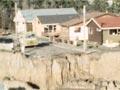
On 8 August 1979 a huge area of the Dunedin suburb of Abbotsford slid downhill, taking 17 people and many houses with it. Luckily no one was hurt – but 69 houses were left uninhabitable. The trouble had started more than a decade earlier when residents noticed hairline cracks in concrete paths. The slip moved very slowly until the sudden slide in 1979, which moved at around 3 metres per minute.
This is known as a layered rock landslide – the hill slid on a lubricated layer of clay. The same rock formations (mudstone) cause unstable slopes on the Kilmog Hill, just north of Dunedin. Slope movement is readily visible in the undulating surface of State Highway 1 in this area.
Green Lake
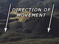
New Zealand’s largest documented landslide occurred some 13,000 years ago in Fiordland. Around 27 cubic kilometres of material collapsed in a hard rock landslide that covered an area of over 45 square kilometres. In effect, a whole chunk of a mountain range collapsed into the valley below. It formed the hummocky terrain typical of many landslides – but on a much larger scale. Some depressions in the surface filled with water, forming sizable holes such as Green Lake, rather than the usual ponds.
Tāhunanui
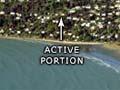
Part of the Nelson seaside suburb of Tāhunanui sits on an active landslide. The hillside overlooking the beach consists of marine sandstone and overlying glacial gravels. In places the gravels are slumping. Damage to houses and property occurred mainly in the 1890s, and in 1929 and 1962 when earthquakes struck. Because of the damage in 1962, a stormwater system was installed to reduce the amount of water entering the landslide. This seems to have helped, but surveys show that the hillside is still slowly slumping in places, and further movement appears most likely when groundwater levels are very high. Since 1985 further building on the slump has been closely controlled, and in certain areas it is not permitted.
King Country rail crash
One of the worst accidents caused by a landslide occurred in 1923. After days of heavy winter rain, the express train from Auckland to Wellington slammed into a huge slip covering the rails at Ōngarue, near Taumarunui. Seventeen people were killed and 30 seriously injured.
Waihī
New Zealand’s highest death toll from a landslide remains the 1846 Waihī disaster, which claimed 60 lives on the shores of Lake Taupō. After heavy rains a landslide blocked a stream, creating a dam behind it. Three days later the dam collapsed sending a mudflow down the valley that overwhelmed the Māori village of Te Rapa, killing chief Mananui Te Heuheu and many others.
In 1910 another landslide killed one person in a new village near the old site of Te Rapa. After this second event the village was abandoned. The source of landslides is an unstable geothermal area known as the Hipaua Steaming Cliffs. This still causes problems for road engineers working on State Highway 41, which passes between the cliffs and Lake Taupō.