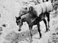


Tracks and rivers
Māori used tracks and waterways to get around. One important track from Ahuriri followed the Esk River and connecting streams to the inland mountain ranges and beyond to Taupō. War parties from the interior of the North Island also used this track.
Extra baggage
Missionaries and their families did a lot of walking on Māori tracks. Elizabeth Colenso, wife of William, travelled more than 200 kilometres overland from the mission station at Waitangi, near Clive, to Tūranga (Gisborne) about six weeks before the birth of her second child in 1845. She was carried in a litter part of the way, but difficult country meant that she often had to walk. In his diary William wrote ‘I shuddered sometimes to see the places Mrs. Colenso had to climb up and down – more than doubly hazardous in the present wet winter season.’ 1
Rivers running down to the coast that were navigable by waka (canoe), such as the Tukituki, were used like highways. The sea was another important thoroughfare.
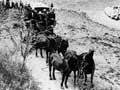
Early European settlers also relied on the Tukituki River to transport goods like wool. They used Māori tracks, some of which were expanded into bullock tracks and roads.
Roads
Early on, Napier and its port became the commercial centre of the region, so roads connecting it with outlying towns were a priority. The Napier–Waipukurau road was started in the late 1850s and was useable by 1860. A bridle track (suitable for horses but not wheeled vehicles) was formed between Napier and Wairoa in the 1860s, and a wider dray road in the late 1890s.
Car culture
Bernard Chambers, winemaker and owner of Te Mata Peak, brought the first car (an Oldsmobile) into Hawke’s Bay in 1902. By 1927 there were 7,000 cars in the region, about one for every 10 people; by 1966 there were 2.7 for every 10 people. On the day of the 2006 census, 65% of employed people in Hawke’s Bay travelled to work by private or company vehicle. Only 7% biked or walked or jogged, and just 0.36% took a bus.
A military road was built inland to Taupō between 1869 and 1872. Other roads were built over the Kaweka Range to the Rangitīkei district (ironically known as ‘Gentle Annie’) and in southern Hawke’s Bay from the 1860s and 1870s. A number of roads had been built throughout the Heretaunga plains by the turn of the 20th century, and routes to other regions were completed by the 1930s.
Small rural populations made financing and maintaining roads difficult. The many streams and rivers in the region meant expensive bridges, and roads in the hills and mountain ranges required extensive earthworks.
There are four state highways in Hawke’s Bay:
- State Highway 2 (Woodville to Mōrere)
- State Highway 5 (the Hawke's Bay section runs from Eskdale to Tarawera)
- State Highway 38 (the Hawke's Bay section runs from Wairoa to Lake Waikaremoana)
- State Highway 50 (Takapau to Napier via Ongaonga and Tikokino).
The region has many unsealed roads, particularly along the coast south of Cape Kidnappers and in the western mountain ranges. In 2009 the Central Hawke’s Bay District Council maintained 406 kilometres of unsealed road – nearly half its entire network.
Shipping and ports
Coastal shipping was an early form of transport used by whalers and flax traders.
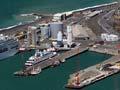
Napier has always been the region’s main port. The inner harbour at Ahuriri was used until a breakwater was built on the outer coast in the 1890s. The 1931 earthquake lifted the seabed and Ahuriri could no longer be used by larger ships.
In the 2010s the major types of export cargo handled by the port of Napier were wood products, foodstuffs, wool and animal by-products. Major imports were oil products, cement, fertiliser and consumer goods imported for sale by local businesses.
Smaller ports were located at Wairoa and Waikōkopu, near Māhia. Coastal vessels also visited smaller bays to collect cargo such as wool. Farmers relied on this service until road and rail networks improved in the early decades of the 20th century. None of these ports or bays are now used for commercial transport.
Rail
A railway line between Napier and Hastings opened in 1874. The line reached Waipukurau in 1876, Dannevirke in 1884, Woodville in 1887, and Palmerston North via the Manawatū Gorge in 1891. A branch line connecting Woodville to Masterton opened in 1897.
The line north proceeded more slowly. The Napier–Wairoa line was opened in 1937 and the line to Gisborne was completed in 1943.
The Bay Express passenger service from Gisborne to Wellington via Hawke’s Bay was cancelled in 2001. In the 2010s the region’s railway lines generally carried freight traffic, though passenger trains on special tours sometimes passed through.
Power generation
Hydroelectric power stations were built on waterways flowing from Lake Waikaremoana between 1926 and 1948 as part of a larger North Island power scheme. The area’s high rainfall made it an obvious choice, but it was a difficult location – tunnelling through a slip near the lake took four years and conditions were described as the most difficult in the country.
Air
Napier and Hastings competed for the region’s main airport in the 1950s. The first airport had been built in Napier in 1932, on land raised by the 1931 earthquake. By the 1950s, when improvements were needed, Hastings was growing faster and its politicians argued that a new airport should be built at nearby Bridge Pā. A government committee decided in Napier’s favour because it already had an established airport.
Hawke’s Bay Airport at Napier hosted 23,500 aircraft movements and 750,000 passengers in the 2018/19 fiscal year. Aerodromes catering for smaller operators and pilot training are in Dannevirke, Pōrangahau, Bridge Pā, Waipukurau and Wairoa.