Hawke’s Bay is on the eastern side of the North Island’s central chain of mountains, and between East Coast in the north and Wairarapa in the south. Its varied landforms are an expression of the active tectonic forces under its surface.
Hills and ranges
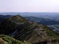
The Ruahine Range, the southern portion of the region’s western boundary, is part of the North Island main ranges. Tall but narrow, it rises sharply from the south to its highest point (1,733 metres above sea level) at the Mangaweka dome. It is composed of greywacke and argillite rock. The Kaweka Range and other smaller ranges lie north of the Ruahine Range.
Tramping mission
Missionary William Colenso was a keen explorer and botanist. When he first heard about the Ruahine Range in 1843, he was determined to cross it and collect botanical specimens, despite Māori chiefs telling him that many had died on its snowy peaks. After pressing an unwilling guide into service in 1845, he got as far as the Te Atua-o-Mahuru summit near the Makaroro River (500 m up the eastern slope of the Ruahine Range, 5 km north of Waipawa), before turning back because his party had run out of food. In 1847 he crossed the range from the west side.
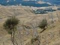
The hills and ranges in central and northern Hawke’s Bay are made of mudstone, limestone, sandstone and argillite. The mudstone hills, which predominate, erode easily. The land between Lake Tūtira and Wairoa is particularly vulnerable to slips. The limestone ranges and hills from Havelock North south are harder rock.
Plains
Running from northern Wairarapa into Hawke’s Bay is a belt of flat land made up of soft, sedimentary rocks deposited by rivers. It is hemmed in by mountain ranges and hills on either side. The plains are narrow in southern Hawke’s Bay but widen into the Ruataniwha and Heretaunga plains south of Napier.
Dinosaur lady
In 1975 amateur paleontologist Joan Wiffen became the first person to discover and verify dinosaur fossils in New Zealand. Until then it was believed that dinosaurs never existed in this country, but Wiffen’s work provided clear proof they had. She found the fossils in Mangahouanga Stream in northern Hawke’s Bay (north-west of Kotemāori), which has since proved to be a rich source of prehistoric remains.
Coast
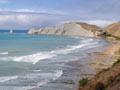
The Hawke’s Bay coast can be divided into two sections – the crescent of Hawke Bay between Māhia Peninsula and Cape Kidnappers, and the long, mostly straight, coast between Cape Kidnappers and Cape Turnagain to the south. Both have tall cliffs interspersed with sandy and stony beaches.
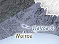
Māhia Peninsula was lifted from the sea floor, and was once an island. The tombolo (sandspit) that created the peninsula formed between Māhia Beach and Ōpoutama in the last 10,000 years. A coastal plain made up of greywacke gravel runs between Māhia and Wairoa.
Earthquakes
Hawke’s Bay is on the Australian tectonic plate near its intersection with the Pacific plate. The Mōhaka Fault (the northern part of the Wellington Fault) runs along the western ranges. These factors make Hawke’s Bay one of the most seismically active regions in the country.
Twenty earthquakes with a magnitude of 6 or greater were recorded in Hawke’s Bay between 1848 and 2001. The earthquake most destructive to life and property was the 1931 Hawke’s Bay earthquake (magnitude 7.8), which hit when the region was already well built-up.
Waterways
The Wairoa, Mōhaka and Esk rivers run down from the ranges in the north. The Tūtaekurī, Ngaruroro and Tukituki rivers flow through the central plains. All drain into the ocean on the east coast. The Manawatū River rises in southern Hawke’s Bay and runs through the Manawatū Gorge to reach the sea on the west coast.
The chain of lagoons between Wairoa and Māhia Peninsula form the biggest wetland system on the east coast of the North Island. The largest estuaries in the region are at Ahuriri and Pōrangahau. Waikaremoana is the largest lake.
Climate
Hawke’s Bay has a generally dry, warm climate because it is sheltered on the west by the North Island’s main mountain ranges. The region has 2,100–2,200 hours of sunshine each year, and the Heretaunga plains have even more. Napier holds the record for the most sunshine hours in a year for a North Island centre – 2,588 in 1994. In summer the maximum daytime temperature is usually 19–24°C. In winter, the usual daily maximum is 10–15°C.
Rainfall is highly variable – summer can have droughts or heavy rains. The inland mountains and some coastal ranges receive the most rain (1,600–2,400 millimetres per year), followed by the inland hills and southern Hawke’s Bay (1,200–2,400 millimetres). The central plains receive 800–1,200 millimetres. The Heretaunga plains often receive less.
In winter Hawke’s Bay is subject to cold southerly winds.
Droughts and floods
Droughts and dry spells are common in lowland Hawke’s Bay. Most of the dry periods occur between October and March.
Floods are the most common form of natural hazard in the region. They occur when a depression moves over northern New Zealand and moist easterly air is forced to rise when it reaches the western ranges. This causes heavy rainfall, which flows down rivers and streams to the lowlands.