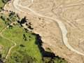
From about 14,000 years ago, as the climate warmed, ice age glaciers shrank rapidly. But 12,000–11,000 years ago they advanced again, building prominent rocky moraines such as the Waiho Loop. This semi-circular ridge marks how far the Franz Josef Glacier advanced into the flats of the Waiho River.
Since then, the glaciers of the Southern Alps have continued an irregular retreat. They reached their minimum size about 6,000 years ago, when the climate was warmer than now. There have been minor advances during cooler periods such as the ‘Little Ice Age’ between the 15th and mid-19th century. Between 1962 and 2018, New Zealand glaciers lost 38% of their volume.
Ice-sculpted mountains
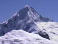
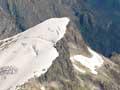
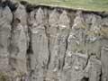
New Zealand’s mountain scenery bears the unmistakable imprint of the ice age. Armoured with rock debris, moving ice scours the rock it moves over. Valleys develop U-shapes, with steep walls and rounded bottoms, while the ridges between them are often sharpened to knife edges. Bowl-shaped areas called cirques are scooped out at the top of glaciers. Where many cirques form on a mountain it may be reduced to a ‘horn’ peak. Mt Aspiring has developed its distinctive ‘Matterhorn’ profile in this way.
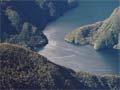
Features created by ice age glaciers are best preserved in areas with hard bedrock, such as Fiordland. Here are vertigo-inducing valleys, such as those crossed by the Milford Track, and a maze of majestic fiords – glacial valleys now filled by the sea.
By contrast, the greywacke bedrock slopes of the Aoraki/Mt Cook region have crumbled rapidly as the glaciers retreated. The steep valley sides have become covered with sloping screes and the valley bottoms buried under river gravel.
Glacial lakes
The South Island has hundreds of lakes formed by glacier activity, ranging from tiny mountain tarns to 60-kilometre-long Te Anau, which is over 400 metres deep.
Most small lakes at high altitude form in glacier-dug rock basins, known as cirques. One example in Fiordland is Lake Quill, which overflows to form Sutherland Falls, arguably New Zealand’s highest waterfall.
The great scenic lakes of the South Island are long and narrow, as they fill valleys carved out by major ice age glaciers. They include:
- Hauroko, Monowai, Manapōuri and Te Anau in Southland
- Wakatipu, Wānaka and Hāwea in Otago
- Ōhau, Pūkaki, Tekapo and Coleridge in Canterbury
- Rotoiti and Rotoroa in Nelson.
The glaciers have carved out these lakes to a great depth (the floors of Manapōuri, Te Anau and Wakatipu lie below sea level). Most are partly dammed by glacier rock debris.
Gold and greenstone
Ice age glaciers carried gold from the Southern Alps into the gravel beds of rivers and streams. Fine gold was also flushed downriver and spread along West Coast beaches. The glittering bonanza sparked the 1860s Otago and West Coast gold rushes. Glaciers moving down valleys such as the Taramakau and Arahura carried another treasure – pounamu or greenstone – to valleys more accessible to Māori.
Loess
Glacier meltwater rivers carry ‘rock flour’ – fine, ground-up sediment that gives the water a milky appearance. Lakes such as Tekapo and Pūkaki are still fed by rivers draining from glaciers, and the rock flour turns them a striking milky turquoise.
During the ice ages, wind picked up fine silt from the open flats of glacier-fed rivers. It was spread across the countryside, covering it with thick blankets of sediment known as loess. Banks Peninsula, for example, became coated with metres of loess blown from the river beds of the Canterbury Plains during the glacial periods.