Ice on the move
A glacier is a huge river of ice, moving slowly down sloping terrain. Glaciers form above the permanent snowline, where winter snowfall exceeds the amount of snow that melts in summer. Snow builds up over many years, compacting to form glacier ice. Gravity sends a glacier creeping downwards, slowly deforming internally and sliding on its base. When it reaches lower, warmer altitudes, the ice melts as fast as it moves. Most of the melting takes place in summer.
New Zealand’s glaciers are fed by snow carried on the moisture-laden winds in the stormy latitudes known as the roaring forties. East of the main divide in the Southern Alps, up to 20 metres of fresh snow may be added each year to the upper Tasman and Hooker glaciers. Even greater volumes fall on the western side of the Southern Alps.
How many glaciers are there?
In 1966 it was estimated that there were about 370 glaciers in New Zealand. An inventory taken in the 1980s by Trevor Chinn and assistants listed more than 3,100 glaciers larger than a hectare. The number of glaciers had not greatly increased – it was simply that they had never been systematically counted before. By the early 2020s, following several decades of warmer temperatures, there were fewer than 3,000 glaciers.
North Island glaciers
In the North Island, only volcanic Mt Ruapehu (2,797 metres) has glaciers. There are 18, including one within the crater. The three largest are the Whangaehu, Mangatoetoenui and Summit Plateau glaciers. An active volcano, Ruapehu has occasionally spurted ash and rock debris over them, and its volcanic heat tends to accelerate melting.
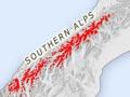
South Island glaciers
The South Island has glaciers from Fiordland to Nelson. The headwaters of the Rakaia and Rangitātā rivers have hundreds, including Lyell and Ramsey glaciers, and the Bracken, Garden of Eden and Garden of Allah snowfields. Only a few dozen are found north of Arthur’s Pass, mostly in the Spenser Mountains and St Arnaud Range.
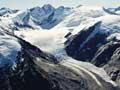
Most of New Zealand’s largest glaciers are in the Southern Alps, which have the highest mountains and heaviest precipitation (rain, snow, sleet or hail). Glaciers in the Aoraki/Mt Cook area include the 29-kilometre-long Tasman, the Murchison (18 kilometres), the Mueller, Hooker and Godley east of the main divide, and the Fox (13 kilometres) and Franz Josef (12 kilometres) west of the divide.
South of Aoraki/Mt Cook, major glaciers including the Bonar and Volta are centred around Mt Aspiring. Many, including the Olivine Ice Plateau, lie in the upper catchments of the Arawata, Matukituki, Dart and Hollyford rivers. They are scattered throughout Fiordland, but concentrated around Mt Tūtoko in the Darran Mountains. New Zealand’s southernmost glacier ice is on Caroline Peak above Lake Hauroko.
Planes as markers
In 1943, a plane crashed on Franz Josef Glacier. Six years later, wreckage appeared at the glacier’s lower end, 3.6 kilometres from the crash site. In 1952, a plane was wrecked on the Mangatoetoenui Glacier on Mt Ruapehu. It emerged 31 years later, just 600 metres further down. It was clear the two glaciers were moving at different rates. Franz Josef moved very fast – about 600 metres per year. The Mangatoetoenui was much slower, moving about 20 metres per year.
Rocks in the ice
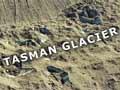
Glaciers act like conveyor belts, carrying rocky debris. As the ice melts, this debris emerges at the surface. On the lower reaches of some glaciers, such as the Tasman, the ice is barely visible beneath the rocks. Some of the rocks are dumped as ridges of moraine along the sides and terminus (front end) of the glacier, outlining the limits of the ice.
Some arid eastern South Island mountains, such as the Ben Ōhau, Two Thumb and the Inland Kaikōura ranges, have developed ‘rock glaciers’. These creeping masses of ice-cemented rubble occur where winter snow mixes with rockfalls from surrounding cliffs. Deep inside they contain a core of glacier ice.
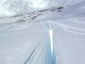
Crevasses
As glaciers lumber downhill over rough terrain, the brittle surface ice often forms deep cracks known as crevasses, up to 40–60 metres deep. These are a deadly hazard for alpine travellers, especially when hidden by snow. On very steep slopes, glaciers may break up into icefalls, such as Aoraki/Mt Cook’s Hochstetter Icefall, with cascades of towering, jumbled blocks of ice.