A climate roller-coaster
During the last 2.5 million years, earth has been plunged into a series of ice ages lasting many tens of thousands of years. In an ice age, global average temperatures drop markedly, major ice sheets build up in the northern hemisphere, and glaciers expand. At times, ice covered more than a quarter of the earth’s land area. As water became locked up in the massive ice sheets, the level of the oceans fell, often by more than 100 metres.
Interglacial periods
Between ice ages the climate resembled that of today, and at times was even warmer. For example, in New Zealand kauri forests and red subtropical soils extended as far south as Wellington. However, these balmy interludes rarely lasted more than 10,000 years.
Glacial periods
In New Zealand, the surrounding oceans moderated the harsh glacial climate, so average temperatures were only around 4° to 5°C lower than today. Auckland’s glacial climate probably resembled that of present-day Dunedin, and Wellington’s that of Norway.
In the mountains, the permanent snowline was over 800 metres lower. Huge glaciers covered the peaks and filled the large river valleys from Fiordland to west Nelson. Smaller glaciers even formed on Stewart Island and the North Island’s Tararua Range, as well as on the central volcanoes.
The Ross Glaciation
The earliest traces of New Zealand glaciation are the layers of sediment at Ross, in Westland. They may have been laid down more than 2.5 million years ago, in what is known as the Ross Glaciation. Deep-ocean deposits drilled offshore show that the climate has alternated between warm and cold as many as 20 times since then, with nine South Island glaciations in the last 700,000 years.
Only patchy traces of the early glaciers remain. They were eroded on the rapidly rising mountains, or were overrun and destroyed by later glaciers.
New Zealand united
During glacial periods the sea level dropped and wide areas of sea floor were exposed around the coast. New Zealand became a single large island. The North and South islands were joined across Cook Strait, and Stewart Island was joined to Southland. Large inlets such as Hawke’s Bay, the Hauraki Gulf and Firth of Thames were dry land.
The Ōtira Glaciation
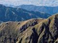
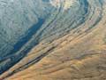
Most is known about the most recent glacial period – the Ōtira Glaciation, between 75,000 and 14,000 years ago. By this time, the rising Southern Alps had developed their present pattern of ranges and valleys, down which ice moved. The landscapes of the Southern Alps were mostly sculpted by ice as it advanced and retreated during this period.
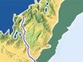
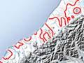
The last advance of Ōtiran glaciers reached its greatest extent around 18,000 years ago. The area they covered is evident from moraine ridges – the heaps of rock debris that built up along the glacier’s edge. On the South Island’s West Coast, ridges hundreds of metres high reach the coast, and sonar mapping shows they extend many kilometres from shore under the Tasman Sea.
In the eastern South Island, moraine remnants show that ice once reached the top of the Canterbury Plains.
Fiordland appears to have developed an extensive ice cap, as the glaciers have rounded off the mountain summits, as well as scouring deep valleys westward to well below today’s sea level. Large amounts of ice from the Fiordland region also filled Southland’s Te Anau and Manapōuri basins, now filled by spectacular lakes.