
This magnificent expanse of inland high country between the Kaimanawa and Ruahine ranges is named after Pātea, who centuries ago sought safety in the district after a murder in Heretaunga (Hawke’s Bay).
Missionary William Colenso traversed the district in 1847 on a return trip from Hawke’s Bay to Taupō. Today it is mostly a place of sheep and cattle stations and the route of the Taihape–Napier road, known colloquially as ‘Gentle Annie’. In the late 1860s, rumours of gold sparked expeditions into the Kaimanawa Range. Until the forest to its west was cleared and the main trunk railway went through, access to the district was from Napier.
Ōpaea
Locality 6 km north of Taihape. The Ōpaea marae meeting house, Tumakaurangi, was built in 1896.
East or west?
By 1898, wool from Moawhango was being transported to the railhead at Mangaōnoho, then west to Whanganui by rail. However, before the main trunk railway was built, most wool went east to Napier.
Moawhango
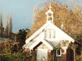
Locality 18 km north-east of Taihape on the Moawhango River. The 1868 settlement expanded after R. T. Batley opened a store in 1882 to service farms in inland Pātea. In 1902 a private memorial chapel was built from locally made bricks in memory of Batley’s eldest daughter, who had drowned in the South Island. After the main trunk railway reached Taihape in 1904, it displaced Moawhango as the area’s main service town. Whitikaupeka meeting house was built in 1893–94, and Whitikaupeka Māori Church in 1904 in memory of the elders of Ngāti Whitikaupeka. Moa bones were found in 1930 in a cave near Moawhango.
Moawhango River
Major tributary of the Rangitīkei, which arises on the western slopes of the Kaimanawa Range and joins the Rangitīkei near Taoroa Junction, 18 km south-east of Taihape. In 1979 the upper Moawhango was dammed to form a 650-hectare lake north of Waiōuru. Water is diverted from the lake by tunnel and canal to Lake Rotoaira as part of the Tongariro power scheme.
Ōhinewairua
Sheep station 29 km north-east of Taihape. Until 1897 it was part of the 46,580-hectare Ōruamātua Kaimanawa block between the Moawhango and Rangitīkei rivers, which was leased by Azim and William Birch in 1867. A clay house, Ōruamātua, built in 1868, is still standing.
Dangerous droving
Erewhon station in the 1870s carried around 80,000 sheep. The wool was taken to Napier by packhorses or mules, with a stockman in charge of each team of 10, and one animal in five carrying fodder and supplies. The train had to negotiate the narrow track into the Ngaruroro River valley and out again, and if it missed its step it bounced to its end in the gorge, 100 metres below.
Erewhon
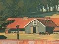
Sheep station (originally spelt Erehwon, the reverse of ‘nowhere’) 34 km north-east of Taihape. Until 1897 it was part of the Ōruamātua Kaimanawa block, leased by the Birch brothers. The homestead was built with locally made bricks in 1884. Black Hill and Springvale stations, 3 km further on, were also part of the original lease. The Springvale suspension bridge across the Rangitīkei, built in 1924–25, survives next to its 1970 successor. A side road 51 km from Taihape leads to Mangaōhane Station.
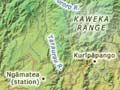
Ngāmatea
Sheep station 56 km north-east of Taihape, part of the Ōwhaoko block and first leased in 1878. It eventually became one of the largest sheep stations in the North Island, extending between the upper Rangitīkei and Ngaruroro rivers and the Kaimanawa, Kaweka and Ruahine ranges. In 1972 the area between the Taruarau River and Kaweka Forest Park became Timahanga Station.
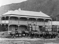
Kurīpāpango
Locality 77 km north-east of Taihape. A two-storey hotel was built on the west bank of the Ngaruroro River in 1882, but was moved across the river beside another hotel soon after. Today the original site is a picnic and camping ground.
Rangitīkei River
The Rangitīkei River arises on the eastern slopes of the Kaimanawa Mountains and flows south and south-west 185 km to reach the Tasman Sea between Moanaroa Beach and Tangimoana. The Moawhango River joins it near Taoroa Junction, and the Kawhatau River further south.
For much of its course the Rangitīkei flows in a steep gorge, with high greywacke cliffs, and a series of terraces above. Large quantities of shingle are carried along the riverbed. The river is popular for fishing, canoeing, jet boating and white-water rafting. At Mōkai, 20 km south-east of Taihape, is an 80-m bungy jump, the North Island’s highest.