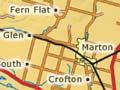
Marton
The largest town in Rangitīkei and the second largest in the region after Whanganui, with a 2013 population of 4,548. Marton is 3 km west of State Highway 1 and 5 km north-east of State Highway 3. The settlement developed in the mid-1860s when four private speculators began subdividing. It was originally called Tūtaenui (dung heap). In 1869 it was renamed Marton after the birthplace of British navigator James Cook, exactly 100 years after he first landed in New Zealand. It became a borough in 1879, when it had a population of 593.
In 1885 Marton became the junction of the main trunk and New Plymouth rail lines. Through most of the 20th century it serviced both the railway and a rich farming district. The town acquired a gracious feel, with large houses in spacious gardens, and private schools: Huntley (an Anglican primary school for boys); Turakina Māori Girls’ College; and Nga Tawa, the Wellington Diocesan School for Girls.
Railway downsizing in the 1980s and 1990s affected Marton, but a more dramatic impact came in the late 1990s. The town’s population had reached 5,301 in 1996, but by 2001 had dropped to 4,713 – partly because nearby Lake Alice Hospital had closed in 1999. Thriving businesses today include Gallagher Fuel Systems, which sells electronic fuel pumps throughout Australia and New Zealand. Eight roads lead into Marton, making it the hub of a wagon wheel, locals say. On the spokes are found, clockwise from the north-east:
- Tūtaenui, where a returned soldiers’ settlement was established after the First World War
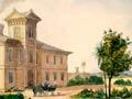
- Crofton, the site of a projected township subdivided in the early 1860s by statesman and social reformer William Fox – he stipulated prohibition, which limited its development
- Mākirikiri South (known locally as South Mākirikiri), where several German families settled from 1860. Marton has had a Lutheran church, St Martin’s, since 1876
- Bonny Glen and Fern Flat (known locally as Fern Flats), which, like Turakina, were settled by Highland Scots.
Scotts Ferry
Settlement 19 km south-west of Bulls near the mouth of the Rangitīkei River, named after Thomas Scott who started a ferry service in 1849. The lower river flooded in April 1897, and the ferry site was washed away. With the river bridged upstream, the service ended in 1907. The settlement was also very hard hit by flooding in February 2004. Just beyond it lies Moanaroa Beach.
Greatford
Locality 6 km north-east of Bulls. Historic properties nearby include Westoe, owned by politician Sir William Fox from 1849 to 1885, and Woodendean, home of the Willis family since 1864. On a former part of Woodendean is ANZCO Food’s meat-processing plant.
Santoft
Locality on the coastal plain between the mouths of the Turakina and Rangitīkei rivers. Santoft station was bought by the government for forestry development and returned-soldier settlement after the Second World War. Sambar deer were introduced in 1875 from Sri Lanka. Today they are a protected herd, controlled by balloted hunting within a limited season.
Flocking a dead horse
On private property near Flock House is a monument known as the memorial to Bess. It marks the grave of one of the very few horses to return to New Zealand after deployment in the First World War.
Bulls
Town 40 km south-east of Whanganui and 30 km north-west of Palmerston North, with a 2013 population of 1,515. It is named after James Bull, who ran a hotel and store from 1858. Today many of Bulls’ residents work at the nearby Ōhakea air force base. Local Chris Amon was a Formula 1 racing driver in the 1960s and 1970s.
Bulls has many shops selling antiques and collectables. Scullys toiletries, made from lavender and other natural ingredients, are exported around the world. The Ngāti Raukawa marae, Parewahawaha, was originally on the east bank of the Rangitīkei River, but in 1897 the river changed course and the marae is now on the west bank.
Pārewanui is a former Ngāti Apa centre, 8km south-west of Bulls. The parents of religious leader T. W. Rātana, and his aunt, Mere Rikiriki, are buried in the ground of Wheriko church, which is a monument to Richard Taylor’s mission work in the district. 14 km south-west of Bulls, Flock House operated as a training farm from 1924 to 1989.