Māori stories
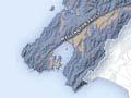
Māori mythology describes how the demigod Māui hooked a huge fish and hauled it out of the sea. His catch, Te-Ika-a-Māui (Māui’s fish), we now know as the North Island. Te Ūpoko-o-te-Ika (the head of the fish) is the Wellington region. The eyes of the fish are Wellington Harbour and Lake Wairarapa.
According to tradition, the harbour was originally a lake. But Ngake, one of two taniwha (water monsters) who lived there, became frustrated at his confinement and used his great strength to carve a route to the open sea – the harbour entrance. His companion, Whātaitai, tried to follow but was washed up exhausted on the southern shore. He is visible today as the hill above Hātaitai (the name is derived from Whātaitai).
Geology
Wellington is the only New Zealand city to be built on a bed of greywacke (a hard grey sandstone). This formed beneath the sea about 230 million years ago, and became hardened. Over the last one million years it has been uplifted to form the North Island’s main mountain ranges. Weathering has changed much of the greywacke around Wellington to yellow clay-rich material – the bane of Wellington gardeners.
Plates and basins
The region lies on the meeting point of two tectonic plates. Twenty to thirty kilometres beneath Wellington, the Australian Plate rides up over the edge of the Pacific Plate, buckling and folding the earth’s surface. Periodically the sudden release of tension causes earthquakes, which can change the landscape.
The Wellington Fault
Movement occurs along three faults – lines of weakness – that cross the lower North Island. One of these, the Wellington Fault, dissects the region. The land directly west of the fault is rising, whereas that to the east is sinking. This movement has created the Upper and Lower Hutt basins. The southern part of the Lower Hutt basin is flooded and forms Wellington Harbour. The northern part (from the Petone foreshore) and the Upper Hutt basin have been filled by gravel and sand, carried down the Hutt River from the Tararua Range.
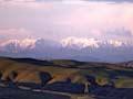
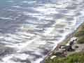
Kāpiti coastal plain
The Kāpiti Coast is another area of flat land – a series of sand dunes and river fans that have gradually been built out from the mountains to form a plain. Ocean currents have added to the coastline by depositing sediment, as well as eroding it. In some areas, large walls have been built to protect the foreshore.
When, not If
Plans for dealing with a major earthquake have been made and the public has been warned. Some experts think that hundreds will be killed. Others predict thousands of casualties, especially on a weekday, when downtown Wellington is crowded. There will also be fires fuelled by broken gas pipes. And the likely clean-up cost? $11 billion.
Epic earthquakes
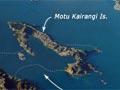
About 1460 CE a massive earthquake, called Haowhenua (the land destroyer) by Māori, raised sections of Wellington’s coastline. The island of Motukairangi was suddenly joined to the mainland – today it is Miramar Peninsula.
The largest earthquake in recent times (magnitude 8.2) was in 1855. It raised the Wairarapa coastline by 3 metres, and land around Wellington by 1–2 metres. The quake brought benefits to the town – it drained Te Aro swamp, yielding new land. The Basin Reserve, intended as an inland dock, became a sports ground. Further afield, a new road was able to be built between Wellington and Petone on a rock platform raised from the sea.
In 1942 two strong quakes damaged city buildings and as a result, architectural ornamentation such as pediments was removed. Two more strong quakes occurred in 2013, and another in 2016 necessitated the demolition of several modern office buildings erected on reclaimed land on Wellington’s waterfront. Because further large earthquakes are likely – even overdue – new buildings are designed to survive. Older buildings must be either strengthened or demolished.
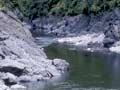
Rivers
The region’s main river is the Hutt. It rises in the southern Tararua Range, flows south-west along the Wellington Fault, then turns south and flows into the eastern side of Wellington Harbour. The other main river is the Ōtaki. Rising on the western side of the Tararua Range, it travels north-west and flows into the Tasman Sea south of Ōtaki.