Halfmoon Bay (Oban)
Halfmoon Bay (also known as Oban) is the township at the heart of the settled part of the island, where all its population of 378 (in 2013) lives. The island’s 25 kilometres of roads, reaching from Horseshoe Bay to Thule, Golden Bay and Ringaringa on Paterson Inlet/Whaka ā Te Wera, stretch from the township.
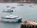
Halfmoon Bay is served by 20-minute plane flights from Invercargill and 60-minute ferry sailings from Bluff.
Stewart Island museum is informative on 19th century Stewart Island life. The Department of Conservation’s visitor centre provides information for visitors to Rakiura National Park, especially trampers, and has historical displays. The library and community centre are on Ayr Street. The local newsletter, Stewart Island News, was published monthly in the 2010s.
The South Sea Hotel is the centre of social life and usually has tītī (muttonbird) on the menu. Other accommodation includes a motel, backpackers, a lodge and a number of private holiday houses that can be rented.
Prior to 1989 Oban was noisy, as households each had their own generators. A centralised diesel power station was built in 1989 and a sewage scheme followed in 1998.
Mud wallows and the Chocolate Swamp
Stewart Island tracks are renowned for degenerating into mud wallows. A notorious section of track between Mason Bay and the Freshwater River was dubbed the Chocolate Swamp before the worst parts were boardwalked in the 1990s.
Rakiura Track
Rakiura Track is a 30 kilometre, three-day tramping circuit out of Halfmoon Bay. It traverses part of the northern shore of Paterson Inlet, including Sawdust Bay and North Arm, and runs cross country between North Arm and Port William/Potirepo.
North-west coast
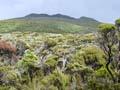
The 125 kilometre North-West Circuit (one of the country’s longest tramping tracks) follows the coast, mainly through forest. A side track reaches to the island’s highest point, Mt Anglem/Hananui (980 m), which has cirques and tarns (hollows and lakes formed by glaciers) – remnants from the last glaciation.
The Ruggedy Mountains line the north-west coast. Orange-brown bluffs and crags protrude from the coastal forest. Wind-formed dune lands, high sand passes and stone fields form an almost lunar landscape in places.
Whenua Hou/Codfish Island
This was an important staging point for birders converging on the Tītī/Muttonbird Islands in their waka (canoes), and was a sealer settlement in the 1820s. Kākāpō have been relocated there from southern Stewart Island.
Are you experienced?
National Park management plans are not usually quote-worthy but Rakiura’s may be an exception: ‘For those who visit Mason Bay an experience of remoteness, space, natural quiet and solitude is gained standing amongst the extensive dunes against the vastness of the Southern Ocean.’1
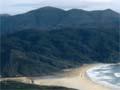
Mason Bay
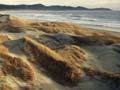
A 15 kilometre arc of sand on the west coast. The Ernest Islands and The Gutter – a little inlet – are at its south end. Dunes up to 200 metres high extend inland for close to 3 kilometres.
The native sand-binding pīngao is making a comeback, helped by the fact that the introduced marram grass, with which it competes, has been sprayed with herbicide.
The former Island Hill homestead was used in the 2010s by the Department of Conservation. Another homestead, Kilbride, still stands near The Gutter. In the past runholders (sheep farmers) would comb for ambergris – a rare sperm whale excretion used in costly perfumes.
Small planes land on Mason Bay and other west coast beaches at low tide.
Southern Circuit
The 71.5-kilometre Southern Circuit tramping track traverses remote and challenging terrain. From Freshwater Landing wetlands are crossed to Mason Bay. The southernmost point is at Doughboy Bay. The track crosses to and descends the Rakeahua valley to the Southwest arm of Paterson Inlet. A side trip reaches Mt Rakeahua (681 m).
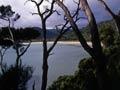
Paterson Inlet/Whaka ā Te Wera
A 8,900-hectare inlet with 188 kilometres of coastline, formed by post-glaciation flooding 12,000 to 16,000 years ago. The Rakeahua River flows into its South West Arm and the Freshwater River near North Arm.
Like Foveaux Strait, Paterson Inlet is named after a lieutenant governor of New South Wales – Joseph Foveaux and William Paterson, respectively. Neither ever saw the waters that took their names.
Ulva Island/Te Wharawhara Marine Reserve was established in 2004 and no fishing is allowed within it. The rest of Paterson Inlet is a reserve with non-commercial fishing only.
A commercial salmon farm is located at Big Glory Bay. Prices Inlet has the rusting remnants of a 1920s Norwegian whaling station. Sawdust Bay is named for the timber mills once found there.
Ulva Island
The largest island in Paterson Inlet/Whaka ā Te Wera. It is named for a small Scottish island, and most of the island has been a scenic reserve since 1892. It is free from introduced predators (deer, rats, wild cats and possums). It has around 20,000 visitors each year, who come mostly via water taxi.
From 1870 early naturalist Charles Traill ran a small post office and general store. Visitors could attach stamps to the large leathery leaves of the coastal shrub Senecio rotundifolius and send a ‘Stewart Island postcard’.