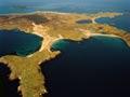

Ruapuke Island
Island surrounded by islets, approximately 32 kilometres north-east of Stewart Island and about 20 kilometres south-east of Bluff. Just over 1,400 hectares in size, the island has no point more than 70 metres above sea level. It is composed of volcanic rocks similar to those found in north-east Stewart Island.
It thrived during the early 19th century whaling era as a centre for Ngāi Tahu leader Tūhawaiki, and a Lutheran mission station was run by Johann Wohlers from 1844 to 1885. In the 2010s it had no permanent population but was frequently visited by fishing boats from both Stewart Island and the mainland.
Tītī/Muttonbird Islands
Rakiura (Stewart Island) Māori gather tītī (muttonbirds) on the 36 Tītī/Muttonbird Islands. Chicks are harvested for two months in autumn. One island group lies west of South West Cape/Puhiwaero; the other lies east of Halfmoon Bay. Tītī are also harvested at other islands around the coast, especially off Port Adventure.
The Neck
Long peninsula at the mouth of Paterson Inlet. A low sandy isthmus – the ‘neck’ – nearly cuts off the upper part.
Excavation of the middens (ancient refuse heaps) of an early Māori settlement has revealed fish, seal, moa, tītī and other bird bones.
A mixed Māori and European population lived on The Neck through the 19th century.
Port Adventure
A bay 10 kilometres south along the coast from The Neck, popular for fishing, diving and hunting. It was the site of a settlement of 36 Māori who arrived from The Neck in 1843.
A large ngaio tree still growing in the 2010s was thought to have been planted in 1856 by Moriori from Rēkohu (Chatham Islands) who had come to rescue kin who had arrived there two years earlier after an unsuccessful attempt to settle the Auckland Islands.
‘Waifs & strays’
Surveyors working in the bush near Port Adventure in the 1870s found two human skeletons. A contemporary newspaper report said, ‘Poor fellows, they were not half-a-mile from the Maori settlement. The remains are believed to be those of two men who ran away from an American whaler (name unknown) at Pegasus about nine years ago … Unlikely castaways, the poor fellows had but themselves to blame for their untimely end; they were truly waifs and strays.’1
South from Port Adventure
The ocean coast is largely rocky with occasional beaches. South of Lords River/Tūtaekāwetoweto it is exposed and mostly cliffs. Subsidence has created drowned river valleys such as Tikotatahi Bay, Tūtaepāwhati Bay and Big Kurī Bay. 500 metres inland salt-tolerant muttonbird scrub yields to podocarp forest.
There is a mix of land status, with Department of Conservation nature reserves, scenic reserve and stewardship land. Rakiura Māori Land Trust land is divided into four blocks – The Neck, Lords River, Toi Toi and Port Adventure.
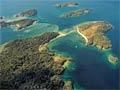
Lords River/Tūtaekāwetoweto
Stewart Island’s largest east-coast estuary, reaching 8 kilometres inland, is a popular anchorage and hunting destination. With no maintained tracks, it is reached by sea.
Six hunting blocks have four huts managed by the Department of Conservation. The Chew Tobacco hunting block and hut is administered by the Rakiura Māori Land Trust. The Toi Toi wetland inland from the river is spiritually important to Māori; waterfowl were hunted there.
In October 1999 the 4,000 Māori owners of 3,515-hectare Tūtae-Kā-Wetoweto Forest received $10.9 million from the government and signed a covenant to remain the owners and kaitiaki (guardians) of the forest.
Port Pegasus/Pikihatiti
A large sheltered harbour on the south-east coast. Its inlets, coves and bays cover some 40 square kilometres, with many safe and sheltered anchorages. Four major passages provide access to the sea. The passages in turn open out into two main arms – North Arm and South Arm.
It was first charted by William Stewart in 1809. A colonisation enterprise in the 1820s was not successful.
Access to the area is mostly by sea. Hunters target red deer and whitetail deer known as ‘grey ghosts’. Campsites are also used by sea kayakers.
Shining domes
Joseph Banks was aboard James Cook’s Endeavour in March 1770 as they sailed down Stewart Island’s east coast. He wrote that the granite domes around Port Pegasus ‘were amazingly full of large Veins and patches of some mineral that shone as if it had been polishd or rather looked as if they were really paved with glass.’2
Around Port Pegasus/Pikihatiti
The high country flanking Port Pegasus/Pikihatiti to the north comprises (north to south) Table Hill, Blaikies Hill, Mt Allen (750 m) and the Tin Range. Although not officially a wilderness area, this area is essentially managed as one.
The subalpine tops support a tundra-like herb cushion community. Shrubs grow in ‘lanes’ in the lee of rocks which protect against ‘roaring forties’ gales.
Flanking Port Pegasus/Pikihatiti to the west are granite domes such as the Fraser Peaks and the Deceit Peaks. As the granite weathers, layers peel away like onion skins to create the domes. They give the area an otherworldly feel.
Farthest south
South West Cape/Puhiwaero and South Cape/Whiore – the southernmost parts of New Zealand – are headlands covered in muttonbird scrub, bearing the brunt of Southern Ocean squalls.