Greywacke mountains
Stretching from East Cape to Cook Strait is the rocky backbone of the North Island – a series of ranges made from greywacke (hard grey sandstone with layers of mudstone). The Raukūmara, Huiarau, Kaimanawa, Kaweka, Ruahine, Tararua, Remutaka and Aorangi ranges are the northern continuation of the Southern Alps, but are rarely higher than 1,500 metres. They form a barrier across the North Island – the Manawatū Gorge provides the only low-level access between east and west.
Most of these ranges were too low for ice-age glaciers to form, and only the Tararuas have a few glacier-smoothed upper valleys.
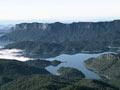
The North Island’s largest wilderness area is in Te Urewera. Forested ridges of the greywacke Huiarau and Ikawhenua ranges form the western part of the area. Lake Waikaremoana, in the east, is flanked by dramatic bluffs. The lake is dammed by a large prehistoric landslide from the end of the Ngāmoko Range.
Eastern hills and lowlands
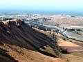
Some of the North Island’s hilly eastern regions are made from soft sediment, laid on the sea floor and later raised above sea level. The material is geologically young, and was never highly compacted.
Stripped of forest and turned into pasture by settlers, these hill slopes of blue-gray siltstone (‘papa’) are prone to erosion. During storms such as Cyclone Bola in 1988, coastal hill country from East Cape to Hawke’s Bay can be devastated by landslides.
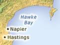
From Hawke’s Bay to Cook Strait, there are a series of lowland areas between the mountain ranges and eastern coastal hills. Bordering south-west Hawke’s Bay are the Heretaunga plains – rich river flats that are home to orchards, market gardens and vineyards.
The largest of the lowland areas is the Wairarapa, stretching northward from Palliser Bay. Sheltered from rain by the Remutaka and Tararua ranges, the grazing country is prone to drought. Vineyards now dot the Martinborough region. North of Eketāhuna the lowland narrows, then widens into the Ruataniwha plains at the foot of the Ruahine Range.
Western lowlands
In the south-western North Island, the Tararua and Ruahine ranges rise sharply above a coastal plain that includes Horowhenua and the Manawatū and Rangitīkei lowlands. The sea has formed terraces at different heights, as the sea level changed during glacial and interglacial periods. Some are now up to 100 metres above the sea.
Between the mouths of the Manawatū and Turakina rivers is New Zealand’s most extensive area of sand country. The dunes, now covered in plants, reach up to 20 kilometres inland. Rivers emerge from the mountains and cross the region, cutting terraces and building flood plains.
From urban to jungle
New Zealand’s capital, Wellington, has a mountain wilderness – the Tararua Range – within sight of its downtown buildings. The range remains remote, and can be crossed only on foot. It has claimed many lives – usually because of unexpected bad weather and fast-rising rivers.
Wellington
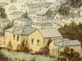
New Zealand’s capital, Wellington, clings to the greywacke hills that surround its superb harbour. Its narrow business district lies on flat land uplifted from the sea by a magnitude 8.2 earthquake in 1855. The city is hemmed in by the southern end of the greywacke ranges and by Cook Strait, and routes in and out are restricted.
The nearby urban areas of Lower and Upper Hutt are on the flood plains of the Hutt River, which flows along the depression created by the Wellington Fault.