Mountainous western Otago
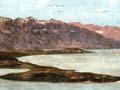
Otago spans the widest part of the South Island. In the west, it includes the glaciated schist mountains of eastern Mount Aspiring National Park. Mt Aspiring (Tititea), known as ‘New Zealand’s Matterhorn’ because of its shape, is the highest peak outside the Aoraki/Mt Cook region, and there are many glaciers on the park’s mountains. To the south and east, lakes Wakatipu, Wānaka and Hāwea fill deep basins dug by ice-age glaciers. Queenstown, on the shore of 80-kilometre-long Lake Wakatipu, is known for its mountain views, especially the jagged outline of The Remarkables.
Central Otago
The landscapes of Central Otago are austere. Broad, rounded summits are covered in tussock and separated by wide basins. The region lies on schist, a flaky, layered rock. The range crests are studded by tors, huge castle-like columns of rock up to 20 metres high, and some of the uplands have mazes of rock outcrops. The terrain is reflected in the names of ranges – Knobby, Raggedy, Rock and Pillar, Old Man, and Pisa.
Sheltered by mountains on all sides, Central Otago is New Zealand’s driest area, and is a major fruit and wine-growing region.
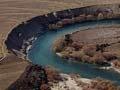
The broad basins between the ranges contain plains, including the Maniototo and Strath Taieri, which are drained by winding rivers such as the Taieri and Manuherikia. Larger rivers such as the Kawarau and Clutha cross the region, flowing from Lakes Wakatipu and Wānaka. The rivers were there before the ranges were uplifted, and have maintained their courses, carving deep rocky gorges through the rising mountains. Terraces along these rivers show that their valleys were alternately filled with gravel and then gouged out, as ice-age glaciers waxed and waned.
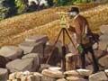
Mind the gap
Māori routes between Wānaka and Southland met at one point – a ‘bridge of stone’ where the Kawarau River could be crossed. The entire volume of the river thundered through a narrow rock slot, 10 metres deep but just 2 metres wide at the top. In 1853, with a Māori guide, farmer Nathanael Chalmers was the first European to leap across.
Eastern Otago
Towards the coast, rainfall increases and the landscape becomes much greener. Cape Wanbrow, near Ōamaru, was part of an undersea volcano. At Moeraki, the beach is strewn with spherical concretions – the Moeraki Boulders – which have fallen from the surrounding mudstone cliffs.
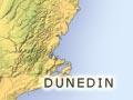
The city of Dunedin lies on the fringes of an ancient volcano, extinct for about 10 million years. The volcano has been deeply eroded by streams, and as the sea rose at the end of the last ice age, it flooded a valley and formed Otago Harbour. The city lies at the head of the harbour.
Some of Dunedin’s western suburbs are built on soft, unstable sedimentary rock. In 1979 a huge landslide in one suburb, Abbotsford, wrecked 69 homes.