

Horse transport
Horses have long characterised the region. Indeed the ‘Nāti’ horse breed, associated with Ngāti Porou, is an icon of the East Coast. Before 1920 there was almost one horse for every man, woman and child. From 1920 motor vehicles reduced the ratio to 1:2, but in rural areas the horse and horse-drawn dray and wagon remained a key form of transport until after the Second World War. C Company of 28 (Māori) Battalion, which drew its recruits from the region, was nicknamed the ‘Cowboys’ because of the number of horses.
Shipping
A breakwater was built at Gisborne by the town’s harbour board in the 1880s, but overseas ships had to anchor in deep water until the 1960s. Nonetheless, by 1896 Gisborne was the eighth-busiest New Zealand port for exports and 10th for imports.
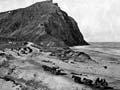
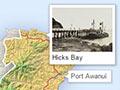
Shipping was critical to the settlements along the coast until the 1930s. Boats carried people, mail and goods in, and livestock, frozen carcasses, mail and people out. Ships called at Hicks Bay, Port Awanui, Tūpāroa, Waipiro Bay, Tokomaru Bay, Tolaga Bay and Whāngārā. Wharves were built or improved in the 1920s, in some instances to service freezing works.
Motor transport and better roads squeezed the life from the ports, and restrictions on shipping during the Second World War were a further blow. After the war only the Tolaga Bay and Tokomaru Bay ports operated along the coast, and their harbour boards were dissolved in 1961 and 1963 respectively.
A rough ride
When Thomas Perry travelled in a service car to Gisborne in 1931, he recorded the trip in his diary: ‘Changed cars [at Ōpōtiki]. 8 cy[linder] Cadillac. Fine car. Climb anything. Woman in back CAR SICK all way ... Motu Gorge wonderful. 24 m[iles] only room most of way for one car to travel. Wonderful bush scenery. Terrific drops side of road in Gorge. Admire driver ... Dark night, blaze of camp fire of Maoris. Very striking ... Gave remains of whisky to woman who was car sick. Glad when I got some back!! Gisborne at last.’1
Roads
Early roads only linked Gisborne to other parts of the Poverty Bay flats; elsewhere there were only bridle tracks and some dray roads. By 1900 coaches could ply both coastal and inland routes to Wairoa, and ran north to Tolaga Bay. In 1914 a coach road was opened to Ōpōtiki via Toatoa, across the ranges from Motu. On the coast road the Waiapu River, a major barrier, was bridged by 1914 and the entire coast route to Ōpōtiki via Hicks Bay was drivable by 1929. The present-day inland route to Ōpōtiki through the Waioeka Gorge opened in 1932.
In the 1920s and 1930s, with passable roads, but no rail, the East Coast provided rich, if unpredictable, pickings for the service cars which had replaced horse-drawn coaches. By 1927 a dozen companies had come and gone on the Gisborne–Napier route. Gisborne-based Robert Kerridge, who later (and much more profitably) operated a national cinema business, ran one of them.
Gizzy ingenuity
A New Zealand-designed bike named the ‘Maori’ was produced in England. Its designers, A. R. Bannister and George Johns of Gisborne, patented its variable speed gear in 1914. The bike was belt-driven, a design that soon lost out to chain-driven bikes.
Rail
At the beginning of the 20th century, East Coast was alone amongst North Island regions in having no railway. It had been too remote during the rail-building drive of Colonial Treasurer Julius Vogel in the 1870s, and was distant from the island’s main trunk route. In the first decade of the 20th century work began on two lines from Gisborne – one north and cross-country to Bay of Plenty, the other south to Napier. The goal was an ‘eastern island main trunk’, following roughly the route of what was to become State Highway 2. The route to Bay of Plenty reached Moutohorā, 50 kilometres beyond Te Karaka, in 1917, but went no further – leaving a more than 100-kilometre gap to the eventual Bay of Plenty terminus at Tāneatua. A coast route south was delayed by the 1930s economic depression the loss of 21 lives in a 1938 flood, war, and engineering challenges, including the 3-kilometre-long Tikiwhata Tunnel and the 1.5-kilometre-long Waikoura Tunnel. It eventually opened in 1942. The line to Moutohorā, which always ran at a loss, closed in 1959.
First flight
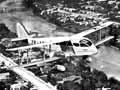
In 1922 Harry Barker, later to be a long-serving Gisborne mayor, was on the first direct flight from Gisborne to Auckland. Anticipating that air travel would be critical in lessening Gisborne’s geographical isolation, he launched a campaign that resulted in the borough council buying land for an airport.
Air transport
Like other isolated regions, Gisborne took speedily to the air and had its first timetabled air service in 1935, before its first rail link. East Coast Airways of Gisborne initially operated the Gisborne–Napier service with DH84 aircraft, and later extended its services to Palmerston North. In 1938 it amalgamated with Palmerston North-based Union Airways. By 1939 it was possible to fly from Gisborne to Auckland (via Ōpōtiki and Tauranga) and Palmerston North (via Napier). Air links north and south have remained important for Gisborne ever since.
Radio
Gisborne local Percy Stevens was making radio broadcasts as early as 1921. He established the station 2YM (later 2ZM and 2XM) in 1923. The Labour government bought out most other stations from 1936, but 2YM remained in Stevens’s ownership until his death in 1963.