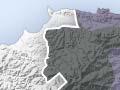

Ranges and hill country
The Raukūmara and Huiarau ranges are composed of greywacke and argillite, formed from old, strongly hardened deep-sea sediments. They make up the two northernmost segments of the North Island’s main dividing range. The fossil clam Inoceramus is found throughout all strata (layers).
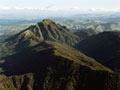
The highest peak in the Raukūmara Range is Hikurangi (1,752 m). Composed of erosion-resistant greywacke, it is the highest non-volcanic peak in the North Island. The summits along the main axis of the range are mostly around 1,400 metres, dipping to about 1,000 metres where State Highway 2 crosses the range. Maungapōhatu (1,366 m), the sacred mountain of the Tūhoe people, is in the Huiarau Range on the western boundary of the region,.
The Pukeamaru massif and the Matakaoa area, in the north-east of the region, are composed of volcanic rocks that date from well before the present mountain-building era. These rocks are generally much stronger than greywacke and form dramatic slopes and bluffs.
The central and eastern parts of the region are composed of mudstone, sandstones and argillite sediments laid down in recent geological times. These have been uplifted by tectonic movement to form steep-to-hilly, easily eroded country.
Oil seepages occur at places in the sedimentary rocks; some have been drilled but amounts that would make extraction financially worthwhile have never been found. The first probes were carried out at Whatatutu in the 1860s, on account of oil seepages there. In the first decade of the 20th century attention focused on Whatatutu again and also Waihīrere. There were further ventures during the depression of the early 1930s and again in the 1960s. In 2011 Petrobras, a Brazilian company, carried out exploratory drilling offshore from East Cape. There were protests from locals, including Ngāti Porou, concerned about the possible environmental impact, and Petrobras handed back its licences in late 2012.
There are varying depths of volcanic ash over the entire region, the result of eruptions in the central North Island.
Rivers and flats
The Waiapu River, with its tributaries, forms the principal catchment in the northern part of the region and was long a barrier to north–south communication.
The Ūawa River follows a lengthy course parallel to the coast from inland of Tokomaru Bay to just before it reaches the sea at Tolaga Bay.
The Waipāoa River drains most of Poverty Bay. The Motu River rises on the Gisborne side of the Raukūmara Range and reaches the Bay of Plenty coast 45 kilometres north-east of Ōpōtiki, via a dramatic gorge through the range.
The Hangaroa River is a tributary of the Wairoa River, which reaches the sea at Wairoa in northern Hawke’s Bay.
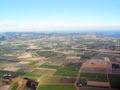
The largest plain is the 18,500-hectare Poverty Bay flats, which are divided into two almost equal parts by the Waipāoa River. The rich alluvial flats, with mild temperatures, produce a variety of crops. Smaller flood plains are found at Te Araroa, and on the lower Waiapu and the lower Ūawa (at Tolaga Bay).
Lakes and wetlands
The region has very few wetlands and lakes, many having been drained to increase the land area used for agriculture, horticulture and settlement.
The most important wetlands (from south to north) are the Wherowhero Lagoon at Muriwai; the margins of Lake Repongaere, near Pātūtahi; Tolaga Bay estuary and nearby Emirau (Loisels); part of the Nuhiti Scenic Reserve, inland from Anaura Bay; Mahora, near Ruatōria; and areas at Te Araroa and Hicks Bay.
Big slip
The Tarndale slip is said to be the largest in the southern hemisphere. It lies on the mudstone banks of the Waipāoa River, inland from Gisborne, and adds a considerable amount of sediment to the river. Forest has been planted on nearby former farmland to slow the growth of the slip.
Erosion
Erosion is a major problem in the region, as its hill country is very liable to land slips. Extensive land clearance has exacerbated the problem, but erosion is also due to the composition and structure of rock and soils. Climate is also a factor, in particular the intense downpours from localised depressions that are common in the region. In recent years plantings of pines have helped combat erosion.
Frequent uplifting of land increases the energy of streams, which leads to the deepening of streambeds and the widening of valleys. This region is uplifting by about 4 millimetres a year, which in geological terms is very fast.
Earthquakes
The region sits on the edge of the Pacific and Australian plates, just to the west of the Hikurangi trench, where the former is subducting under the latter. In 1947 a seemingly minor earthquake was followed by two tsunamis (the first was about 8 metres above normal sea level), which hit the coastline worst between Whāngārā and Tatapōuri.
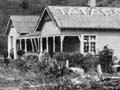
Earthquake tremors in the region have been recorded since 1840. In 1966 a magnitude 6 earthquake struck the region. On 20 December 2007 there was a magnitude 6.8 earthquake in Gisborne. Three buildings collapsed and 23 more were barricaded off and closed. Damage to commercial buildings was $50 million and more than 6,000 insurance claims were made by homeowners.