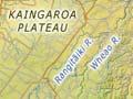

Rangitāiki River
The principal Bay of Plenty river. Its headwaters rise in the Ahimanawa Range, south of State Highway 5 between Taupō and Napier. From there the river finds its way across the volcanic Kāingaroa Plateau, drawing in tributaries, notably the Wheao and the Whirinaki which rise in ranges to the east. The Rangitāiki descends the plateau at Matahina, flowing through what was a large swamp.
Its waters once dispersed into the Awaiti and Orini distributaries, into which the Tarawera and Whakatāne rivers also flowed. Now it reaches the sea 12 km west of Whakatāne.
The Tarawera River rises on the slopes of Tarawera volcano and hugged the western edge of the swamp before reaching the sea east of Matatā. The Whakatāne River rises in the Huiarau Range and followed the eastern edge of the swamp past Tāneatua to the sea at Whakatāne.
Drainage
Attempts to drain the swamp were made from the 1890s. The first sod for the diversion of the river into a channel through the sand barrier at Thornton was turned on 16 March 1911. From 19 May 1914, the river coursed for the first time through the new channel. The swamp was then drained and converted into farmland. The Rangitāiki Plains became some of the most productive dairy country in the Bay of Plenty. The river was dammed for electricity purposes at Matahina, producing a lake upstream. The Wheao River is dammed above Murupara.
Floods
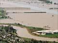
In 2004 severe floods swamped some 17,000 hectares of farmland in the eastern Bay of Plenty after heavy rain. Water had to be released into the Rangitāiki River from the Matahina dam to prevent the dam from bursting. The river overflowed above Edgecumbe, and both that town and nearby Te Teko were flooded.
Matahina
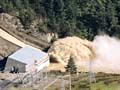
Power station, pine forest and locality on the Rangitāiki River. It lies at the neck of a gorge that cuts into the ignimbrite sheet of the Volcanic Plateau.
The dam
Construction on a hydroelectric dam began in 1959. The power station was commissioned in 1967. Te Mahoe village, still in existence, was built for dam construction workers. The dam was in a geologically unsound location – between 1967 and 1987 it shifted downstream almost 1 metre and moved another 150 mm after the 1987 Edgecumbe earthquake (magnitude 6.3). The dam was later strengthened. There were extensive consultations with the Ngāti Awa tribe, who were prominent in the completion ceremony in August 1998.