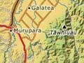
Murupara
Township on the Rangitāiki River on part of its course across the Kāingaroa Plateau, 55 km east of Rotorua. A short distance east of Murupara the plateau ends abruptly against the foothills of the Ikawhenua Range, which dominates the eastern sky. In 2013 the population was 1,656.
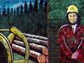
The town was established in the 1950s as a centre for logging the Kāingaroa state forest. Roads and rail connect it to Kawerau, 70 km north, where the logs are processed into pulp and paper. It was constituted a town district in 1954 and a borough in 1962, but was amalgamated into Whakatāne district in 1989. Job numbers fell sharply after the Forest Service was corporatised in the late 1980s.
In 2013 Murupara’s 27.2% unemployment rate was almost four times the New Zealand figure (7.1%). Although 31.2% of the population was aged under 15, the total population was declining (from a peak of 3,000 in the 1970s). 90.8% claimed Maori ethnicity. Ngāti Manawa, the local iwi (tribe), are kin to Ngāti Whare and Ngāi Tū.
We are the people
The traditional saying of Ngāti Manawa is:
Kō Tawhiuau te maunga, kō Rangitāiki te awa
Kō Ngāti Manawa te iwi, kō Tangiharuru te tangata.
Tawhiuau is the mountain, Rangitāiki is the river
Ngāti Manawa are the people, Tāngiharuru is the man.
Galatea
District named after HMS Galatea, in which the Duke of Edinburgh, a son of Queen Victoria, visited New Zealand during an empire tour in 1869. The name was originally applied to the armed constabulary redoubt established during the hunt for Māori leader Te Kooti. Skirmishes took place on 18–19 March 1869 at nearby Tauaroa. Today Galatea is part of a farming district on the Kāingaroa Plateau that stretches from Murupara to Waiōahau. It has a strong Ngāi Tūhoe identity.
The damming of the Rangitāiki River at Aniwhenua in the late 1970s created a 255-ha lake and a waterfall which appears at the regular opening of the floodgates. The lake has a camping site and is popular for fishing and duck shooting. Kopuriki, midway between Waiōahau and Galatea, has a store. A small winery operates in the foothills of Tawhiau, east of Galatea.
Ikawhenua
Westernmost range of the main divide in the Bay of Plenty region. Forming a watershed between the Rangitāiki and Whakatāne rivers, it is divided by valleys, and has altitudes of 300 to 1,300 m. The full name, Te Ikawhenua o Tamatea (land of Tamatea’s fish), links the range to Tamatea of the Tākitimu canoe. The still forested valleys and summits have important associations for hapū of Ngāti Manawa, Ngāti Whare and Ngāi Tūhoe. Tawhiuau, the mountain of Ngāti Manawa, reaches 1,017 m.