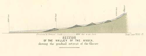
This cross-section of the Avoca valley in north Canterbury was drawn by Julius Haast after he had surveyed the area. The position of the glacier in 1866 is shown on the right, with a series of terminal moraines (gravel ridges) further down-valley, indicating the glacier’s retreat from past positions.
Using this item
Te Ara - The Encyclopedia of New Zealand
Reference: Julius Haast, Report on the headwaters of the River Rakaia. Christchurch: Government Print, 1867
This item has been provided for private study purposes (such as school projects, family and local history research) and any published reproduction (print or electronic) may infringe copyright law. It is the responsibility of the user of any material to obtain clearance from the copyright holder.