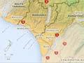

The Whanganui region lies between mountains and the sea. Dominating its northern boundary is Mt Ruapehu. To the north-west is the Matemateaonga Range, and to the north-east the Kaimanawa Mountains and the Kaweka and Ruahine ranges. Between the mountains and the Tasman Sea are rolling hill country with many razorback ridges, and lowlands along the coast. There are striking views of Mt Ruapehu from the highlands and from the coast, some 100 kilometres away.
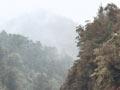
In the north-west of the region, Whanganui National Park contains one of New Zealand’s largest remaining tracts of conifer–broadleaf forest.
A land of rivers
Numerous streams and rivers dissect and drain the region. The Rangitīkei River marks the area’s boundary in the south-east, and at its heart is the North Island’s second longest river, the scenic and historic Whanganui. The river and Mt Ruapehu are seen as sacred ancestors by Whanganui Māori.
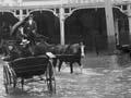
The Whanganui and Rangitīkei rivers and their tributaries have large catchments; the Waitōtara, Whangaehu and Turakina rivers smaller ones. The rivers are prone to flooding – severe floods wreaked huge damage throughout the region in February 2004. The Waitōtara and Whangaehu catchments suffered again in July 2006.
The Whangaehu River, at Tangiwai, was the scene of New Zealand’s worst train disaster on Christmas Eve 1953, when a lahar (volcanic mud flow) washed away a bridge, leading to the deaths of 151 passengers and crew.
Tribal areas, region and districts
Most of the catchment of the Whanganui River is the rohe (tribal area) of the Te Āti Haunui-a-Pāpārangi tribe; Waitōtara–Waverley and part of the Whanganui area are the rohe of Ngā Rauru Kītahi.
Rangitīkei is divided between the tribes of Ngāti Apa and Ngāti Hauiti, the confederated hapū (sub-tribes) of Mōkai Pātea, and the Ngāti Raukawa hapū of Ngāti Parewahawaha.
The region developed from the founding of Whanganui town in 1840. Whanganui’s significance as a town and port was firmly established well before adjacent areas were settled; as European settlement advanced, so did the town’s sphere of influence.
The region comprises Whanganui and Rangitīkei districts, the Waimarino part of Ruapehu district and the Waitōtara–Waverley part of South Taranaki district. All of these areas except Waitōtara–Waverley fall within the territory of Horizons (Manawatū–Whanganui) regional council.
What's in a letter?
Wanganui has long been a spelling of Whanganui, reflecting the fact that local Māori pronounce ‘wh’ as ‘w’. Both spellings of the name were made official in 2009 but locals, both Māori and Pākehā, still expect it to be pronounced with the ‘h’ silent.
History from 1840
European settlers arrived in Whanganui, one of the country’s first towns, from 1841. Wanganui (now Whanganui) Collegiate School was established in 1854, and New Zealand’s oldest surviving newspaper, the Wanganui (now Whanganui) Chronicle, in 1856. The district saw conflict between Māori and government forces in 1847, and again in the 1860s.
European settlement advanced from 1870 – north-west towards Hāwera, and north up the Whanganui, Waitōtara, Turakina and Rangitīkei river valleys.
From 1916 to 1936 Whanganui was New Zealand’s fifth-largest city. But its fortunes, like those of the region, faltered during the depression of the 1930s, and for decades afterwards neither the town nor the region grew fast.
Since the 1990s new industries and innovative businesses have been set up and tourism is flourishing, although the population has not increased greatly.
Heritage
The region is home to many fine Māori meeting houses. Small churches, many designed by Frederick de Jersey Clere, are a distinctive feature of the countryside. There are a number of historic houses and homesteads in Rangitīkei and around Whanganui, and the National Army Museum is in Waiōuru.
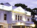
Cultural institutions in Whanganui itself include the Sarjeant Gallery, the Royal Whanganui Opera House, Whanganui Regional Museum and the Ward Observatory. Cooks Gardens is a renowned sporting venue.