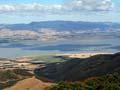
Wairarapa has a sense of space. If you arrive from Wellington by car, the zigzag road over the Remutaka Range offers glimpses of the plain below. At Featherston the hills part to reveal the land’s flatness and breadth. To the left are the blue-green peaks of the Tararua Range. To the right are the rolling grassy hills of the eastern uplands. Above is a vast sky.
Turning south, you pass muddy Lake Wairarapa on the way to Palliser Bay’s wild coastline. To the north along State Highway 2 are the towns of Greytown, Carterton and Masterton.
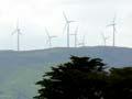
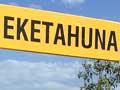
Approached from the north, Wairarapa is signalled by the swooping blades of the Tararua wind farm. At Woodville, State Highway 2 turns south, following a narrow plain to Eketāhuna. Here you can head to the eastern coast through the Waewaepa and Puketoi ranges or continue south to Mt Bruce, a remnant of native forest in the exotic grassland. Towards Masterton the vista opens to reveal the expansive spaces of southern Wairarapa.
Glistening water
On reaching the Remutaka Range summit from the west, the Māori explorer Haunui spied the lake below, and named it Wai Rarapa (‘glistening water’). At first the name referred only to the lake and its environs, but later it came to designate the whole region.
Boundaries
Rectangular in shape, Wairarapa is bordered by the sea to the south and east, and the Tararua Range to the west. Its northern edge is an imaginary line running from the Manawatū Gorge to Cape Turnagain.
The region is usually divided (around Mt Bruce) into northern and southern zones. The north is part of the territory served by Horizons (Manawatū–Wanganui) regional council. The south is served by the Greater Wellington regional council.
Beyond meat and butter
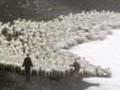
Wairarapa is one of New Zealand’s most rural regions. Only 71% of its people live in urban areas, compared to 85% nationally. Agriculture is the largest single industry and employer. Previous over-reliance on livestock farming exposed the region to a boom–bust trading cycle, and recently its economy has diversified. Once largely known for meat and butter, Wairarapa now produces quality wine and fine food. It is also promoted as a holiday and lifestyle destination.
Wairarapa people
Archaeological sites show that Māori first settled in Palliser Bay in the 14th century. Later, people from the Rangitāne and Ngāti Kahungunu tribes established a strong presence in the region. From the 1840s European farmers joined them. Turning bush into pasture, they colonised the landscape, many growing rich off the sheep’s back (wool) and the cow’s udder (milk, butter and cheese).
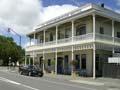
Towns were established from the 1850s, attracting more people to the region. Relations between Māori and Pākehā were friendly – Wairarapa stayed out of the New Zealand wars – but as Pākehā prospered, Māori lost most of their land and wealth. After 1945 many Māori moved to towns and found jobs alongside Pākehā in rural processing and other industries.
Social problems
In the 1980s many jobs were lost through economic restructuring. This enlarged the urban underclass and made chronic social problems worse, with high rates of deprivation and abuse.
Since then, the rural communities have become wealthier than the urban ones, especially as affluent lifestylers have arrived from Wellington.