
Wairarapa is shaped like a rectangle, about 130 kilometres long (from Palliser Bay north to Woodville) and 65 kilometres wide (from the Tararua and Remutaka ranges east to the coast). The Ngāti Kahungunu tribe’s Wairarapa Tāmaki-nui-a-rua administrative boundary for the region is similar, stretching from Pōrangahau to Turakirae. It is the southernmost of their three rohe (homelands) running down the eastern North Island from Wairoa. For the Rangitāne tribe, Wairarapa is part of a wider homeland that includes Manawatū and Horowhenua.
In the 19th century Wairarapa was administered by the Wellington provincial government, along with Hawke’s Bay. When Hawke’s Bay broke away in 1858, the province’s new northern border stretched from the Manawatū Gorge east to Cape Turnagain.
Regional identity
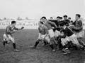
Wairarapa acquired a distinct identity after the Wairarapa and Bush rugby unions were formed in the 1880s and 1890s. They often combined to play touring teams. A sense of regional unity was reinforced by local newspapers, including the Wairarapa Daily Times and the Wairarapa Age. These merged in 1938 to form the Wairarapa Times-Age, the region’s sole surviving daily.
Ground-breaking Georgina
One of Wairarapa’s most famous politicians was Georgina Beyer (1957-2023). Elected to the Carterton District Council in 1993, she was New Zealand’s first transgender councillor. Two years later the town made her the world’s first transgender mayor. She achieved another world first in 1999 when she became a member of Parliament.
However, regional identity was not as strong as in other areas, largely because Wairarapa has never had a capital city. Masterton quickly became the largest centre, but has never been big enough to dominate the region. People in southern Wairarapa think of Wellington as their ‘big smoke’, and those north of Eketāhuna look to Palmerston North.
Government
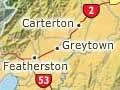
The north–south divide was reinforced in 1989, when local authority boundaries changed. The new Tararua District Council covers northern Wairarapa and southern Hawke’s Bay. Central and southern Wairarapa was divided into three district councils: Masterton, Carterton and South Wairarapa.
In terms of national politics, when the proportional representation electoral system was introduced in 1996, the Wairarapa electorate expanded to include southern Hawke’s Bay.
Regional loyalties may eventually be realigned because of these changes, but for now Wairarapa’s (unofficial) northern border remains Manawatū Gorge to Cape Turnagain.