
The thick mantle of ignimbrites and tephra-fall layers forming the central North Island landscape is clear evidence of many large volcanic eruptions over the last few thousand years and earlier.
Debate about volcanic hazards
In 1920, Thomas Jaggar, Director of the Hawaii Volcano Observatory, reported on the need for volcano surveillance in New Zealand, but his recommendations were not implemented. However, his visit initiated detailed mapping of volcanic rocks in the Taupō Volcanic Zone by Leslie Grange from 1926 to 1929. Grange reiterated the need for close observation of volcanoes in this region, but no action was taken.
The Tangiwai disaster
In December 1953 a lahar from the crater lake on Mt Ruapehu washed out a bridge across the Tangiwai River, resulting in the death of 151 people from a train crash. This disaster led to recognition that volcanoes likely to erupt again should be regularly monitored. Although an eruption cannot be prevented, monitoring should indicate increased activity before an eruption, allowing for evacuation of people and mitigating the effects on property.
Monitoring natural hazards
In 2006 monitoring of natural hazards (including volcanoes) was the responsibility of GeoNet, a collaborative project between the Earthquake Commission, GNS Science, and the Foundation for Research, Science and Technology.
How are volcanoes monitored?
Before an eruption happens, magma moves up towards the ground surface. Volcanologists use several methods to detect the movement of magma:
- detecting earthquakes
- measuring ground deformation
- monitoring volcanic gases
- monitoring changes in the chemistry and temperature of crater lakes.
Earthquakes usually provide the first sign of unrest. The seismic results are sent by radio telemetry to GeoNet headquarters and continuously monitored. Once increased activity is detected, more detailed observations are undertaken. Earthquakes caused by the rise of magma – identified as ‘volcanic earthquakes’ – can be distinguished from those arising from ground movement caused by tectonic (non-volcanic) processes.
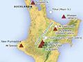
New Zealand’s active or potentially active volcanoes
Those volcanoes that have erupted within the last 10,000 years, especially those with multiple eruptions in that period, are the most likely to erupt again. Together with Taranaki (Mt Egmont) and the Tūhua caldera (Mayor Island), most of the active volcanic centres are in the Taupō Volcanic Zone, and include Ruapehu, Ngāuruhoe, Tongariro, Taupō caldera, Okataina caldera, Mt Edgecumbe (Pūtauaki) and Whakaari (White Island). Eruptions of Whakaari killed 10 people in 1914 and 22 in 2019.
Taranaki (Mt Egmont) has erupted at least a dozen times since about 1300 CE, the most recent (Tahurangi) occurring probably around 1755. Taranaki has generated a series of lahars in the last few thousand years, as well as eruptions, and part of the volcano's summit probably collapsed between 1860 and 1897.
Mayor Island (Tūhua), 25 kilometres offshore in the western Bay of Plenty, has erupted several times in the last 10,000 years. A caldera-forming event about 7,000 years ago spread tephra over part of the North Island. The latest eruption, of lavas, took place possibly about 3,000 years ago.
Mt Edgecumbe (Pūtauaki), an andesitic cone volcano, was active about 3,200 years ago.
Small eruptions have occurred irregularly over a large area in the Auckland volcanic field, the latest being the formation of Rangitoto Island around 1400 CE. Past experience suggests that future eruptions in Auckland are likely to come from new vents rather than existing cones.
All these volcanoes are monitored by the existing seismic network, which should give early warning of renewed volcanic activity. In some cases, however, the period of warning before an eruption may be only a matter of a day or two (as in Auckland) but in others (such as Taupō) it may be prolonged for months or even years.
Kermadec volcanoes
The Kermadec Ridge continues north-eastwards for over 1,400 kilometres from the Taupō Volcanic Zone as a chain of submarine volcanoes. Oceanographic research has shown evidence of recent volcanic or hydrothermal activity. Three volcanic islands occur towards the northern end of the ridge, and there is a seismograph on Raoul Island (900 kilometres north-east of New Zealand). In contrast to the volcanoes on or close to the North Island, there is little monitoring along most of the Kermadec Ridge.