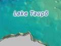
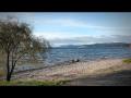
Lake Taupō, the largest lake in New Zealand, owes its existence and shape to the caldera-forming eruptions of the Taupō volcano – the most frequently active rhyolite volcano in the world.
The enormous Ōruanui eruption, about 26,500 years ago, formed the 30-kilometre wide depression at the northern end of Lake Taupō. Since then there have been 28 separate eruptions, ranging greatly in size. The latest (Taupō) eruption occurred about 232 CE, and its effects on the landscape are still visible today.
Radiocarbon dating indicates an uneven spacing of Taupo's eruptions, from decades to thousands of years apart. This makes it difficult to forecast when the next eruption will occur and how big it will be.
Ōruanui eruption
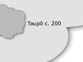
The Ōruanui eruption (about 26,500 years ago) covered much of the central North Island with ignimbrite, up to 200 metres deep. Ash fallout was spread by the wind over the entire North Island, much of the South Island, and a large area east of New Zealand, including the Chatham Islands. About 1,200 cubic kilometres of pumice and ash were rapidly ejected. This caused a large area of land to collapse, forming the caldera basin now filled by Lake Taupō.
Big bang
The Ōruanui eruption was so enormous that it is hard to visualise. In only a few days or weeks it ejected enough material to construct three Ruapehu-sized cones.
After the eruption, the new lake gradually filled to a level 140 metres above the present lake. The lake broke out to the north, resulting in a huge flood. For several thousand years the Waikato River flowed northwards into the Hauraki Gulf, but it later changed its course to flow through the Hamilton lowlands to the Tasman sea.
Taupō eruption
The most recent major eruption of Taupō volcano took place in late summer–early autumn around 232 CE, from vents near Horomatangi Reefs (now submerged).
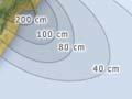
The eruption produced a towering ash column, resulting in tephra-fall deposits over a wide area from Hamilton to Gisborne. The airfall deposits were much thicker to the east of Taupō because the eruption column was blown in that direction by strong westerly winds.
The eruption column was followed by a devastating pyroclastic flow, blanketing a roughly circular area within 80 kilometres of Lake Taupō with ignimbrite, and destroying all life in its path. The ground-hugging pyroclastic flow appears to be one of the most powerful ever recorded, and was able to overtop Mt Tongariro and the Kaimanawa mountains, climbing 1,500 metres in a matter of minutes.
The outlet of Lake Taupō was again blocked during the eruption, and the lake level rose to 34 metres above its present height, forming a widespread terrace. The lake eventually broke out in a huge flood whose effects can be traced for over 200 kilometres downstream, and include boulder beds and buried forests.