Search
… those who indicated more than one tribe), and the regions where they were found in the greatest numbers in … census: 1,197 2006 census: 1,566 2013 census: 2,217 Major regional locations Wellington: 822 Manawatū–Wanganui: 543 … census: 966 2013 census: 1,218 Major regional locations Marlborough: 282 Canterbury: 219 Rangitāne (unspecified) …
Type: Story Page
Part of story: Rangitāne
… There are eight mutually recognised tribes in the Nelson–Marlborough region – Ngāti Kuia, Ngāti Apa and Rangitāne (Kurahaupō … and interacted in an area that included coastal Nelson–Marlborough and across Cook Strait to the North Island. …
Type: Story Page
Part of story: Nelson region
… cars and good roads, sports days in isolated parts of the region were local affairs held in paddocks. Horse racing was … Since 2006 the Tasman Makos have represented Nelson–Marlborough in the Mitre 10 Cup competition. After three … South Island unions – West Coast, Buller, Nelson Bays and Marlborough. Fishing and hunting Nelson’s rivers and streams …
Type: Story Page
Part of story: Nelson region
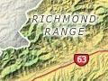
… South Island, and gives its name to the island’s north-west region. The city is the region’s commercial, cultural and … Tasman District Council and the east and south-east by the Marlborough District Council. The city does not include … the tops of the Richmond Range, which separates Nelson and Marlborough. Most of the city’s water supply comes from dams …
Type: Story Page
Part of story: Nelson places
… as at Hokianga and Whitianga. The longest river in this region, the Northern Wairoa, feeds the large, estuarine … are the Motueka, Grey, Taramakau and Arahura rivers. Marlborough and Canterbury Marlborough, Canterbury and South Canterbury are famous for …
Type: Story Page
Part of story: Rivers
… government policies, the people of Te Tau Ihu (Nelson–Marlborough) have survived. The eight tribes of the area are now increasingly significant contributors to the regional economy. A landmark event in Nelson was the … there are eight mutually recognised tribes in Nelson–Marlborough today. The Kurahaupō tribes are: Ngāti Kuia …
Type: Story Page
Part of story: Te Tau Ihu tribes
… Climate In terms of rainfall, Marlborough consists of three climate zones: the dry Wairau … – often the nation’s highest. Picton, like the rest of the Marlborough Sounds, has a higher rainfall and more moderate … Wairau River Board (known as the Marlborough Catchment and Regional Water Board from 1956 to 1989) engaged in extensive …
Type: Story Page
Part of story: Marlborough region
… cherries, and encourage disease. Annual production in each region can vary considerably as a result of these weather … the New Zealand market. Cherries and apricots are grown in Marlborough. Competition for land North Auckland growers … Since the late 1990s, cherry and apricot production in Marlborough has dwindled as grape plantings have expanded or …
Type: Story Page
Part of story: Stone fruit and the summerfruit industry
… second voyage, he liberated goats from England in the Marlborough Sounds in 1773. Later introductions to nearshore … Barrier and Auckland islands, and on Arapawa Island in the Marlborough Sounds). Goats were also released as food for … it was reported that there were about 30,000 goats in the region between Lakes Wānaka and Wakatipu, and four years …
Type: Story Page
Part of story: Goats and goat farming
… for and behave in an emergency is given on the national and regional civil defence websites, and in regular newspaper … Many Civil Defence Emergency Management (CDEM) regions have a text alert system for disasters, and the … the afflictions of these volunteers are genuine. In a Marlborough civil defence exercise in the early 1990s, one …
Type: Story Page
Part of story: Civil defence
… most of the accessible and useable native timber in the region had been felled. Exotic forests were planted throughout northern Marlborough from the 1950s, extensively on the margins of … Native flax ( Phormium tenax ) grew on swampy land around Marlborough; it was harvested and prepared manually by …
Type: Story Page
Part of story: Marlborough region
… is responsible for earthquakes in many New Zealand regions. In the North Island, no subduction earthquakes have … Plate is descending under the eastern North Island and Marlborough. Here the land has splintered into long blocks … such as the 1848 earthquakes along the Awatere Fault in Marlborough, the 1855 Wairarapa earthquake and the 1888 …
Type: Story Page
Part of story: Earthquakes
… Southland consists of three distinct landform regions, which have different geologies. The uplands The mountains in the north of the region are part of the block of schist which forms Central … region is similar in geological composition to north-west Marlborough. The movement along the Alpine Fault has now …
Type: Story Page
Part of story: Southland region
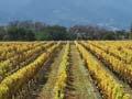
… producing small crops. There are no economic ways to rid a region of phylloxera once it has arrived. It spreads from … to boost the numbers of the rare New Zealand falcon in the Marlborough region, while reducing damage to grapes from … North Island vineyards and by 2004 was becoming common in Marlborough. The virus was transmitted to vines and …
Type: Story Page
Part of story: Viticulture
… local demand. However, mussel beds in Tasman Bay (Nelson region) and the Hauraki Gulf (Coromandel region) were … The sheltered, clean waters of the Hauraki Gulf and the Marlborough Sounds, rich in nutritious plankton, provided an … production on marine farms located predominantly in the Marlborough and Coromandel regions. …
Type: Story Page
Part of story: Aquaculture
… charges such as fees for the use of public swimming pools. Regional councils In 2022 New Zealand had 11 regional councils, which focused on regional environmental … councils – Nelson City Council and the Gisborne, Tasman, Marlborough and Chatham Islands district councils – also …
Type: Story Page
Part of story: Local and regional government
… of oats, 149,000 tonnes of maize and 30,000 tonnes of peas. Regional production In 2002, 68% of New Zealand’s arable … wheat and 80% of wheat used as feed. Other wheat-growing regions were Southland, Otago and Manawatū–Wanganui. … coming from Hawke’s Bay, Manawatū–Wanganui, Wellington, Marlborough, Otago and Southland. In contrast to the other …
Type: Story Page
Part of story: Arable farming
… measurements in New Zealand were made at Ship Cove, Marlborough Sounds, during James Cook’s first visit in 1770. … of the 20th century to identify any magnetically disturbed regions. Another complete magnetic survey of New Zealand was … regular magnetic measurements in the New Zealand region. Local variation in magnetic rocks In some areas, …
Type: Story Page
Part of story: Magnetic field
… frozen vegetables and potato crisps. The main growing regions for processed crops are Gisborne/Hawke’s Bay, Rangitīkei/Manawatū, Marlborough and Canterbury. The principal crops in order of … The main areas of commercial production are Canterbury, Marlborough, Manawatū and Hawke’s Bay. Frozen peas are New …
Type: Story Page
Part of story: Market gardens and production nurseries
… Māui, Kupe and Tamatea-pōkaiwhenua Some early place names in Marlborough link the region with the trickster demigod Māui, whose waka was the … a metamorphosed mudstone, found only in the Nelson–Marlborough mineral belt, including on Rangitoto ki te Tonga …
Type: Story Page
Part of story: Marlborough region