
New Zealand’s earthquakes originate from the collision between the Australian and Pacific plates.
Where two plates meet
New Zealand is the visible part of a largely submerged small continent. The islands New Zealanders live on are the continent’s highlands, thrust above sea level by the collision of the Australian and Pacific plates. The boundary between these two moving plates runs diagonally through the country.
The North Island and its continental shelves, which lie under the sea, are on the Australian Plate, as is the land west of the Alpine Fault in the South Island. The rest of the South Island is part of the Pacific Plate. The pattern of earthquakes in New Zealand reflects the activity of the plates along their boundaries.
Oceanic and continental crust
The huge plates that make up the surface of the planet have two main types of rocky outer layer, or crust. Beneath the floor of the deep oceans is oceanic crust: this is about 8 kilometres thick, and made of dense rock. But most land areas and their offshore continental shelves are made of continental crust. This averages 35 kilometres in thickness and is made of lighter, relatively buoyant rock. Both types of crust may occur on a single plate.
Under the volcano
Volcanic activity can produce several types of seismic activity and earthquakes. Magma and volcanic gases moving through underground conduits can generate volcanic tremor, a fairly continuous ground vibration. As molten rock rises beneath a volcano, however, it may break the surrounding rock, producing small to moderate volcanic earthquakes.
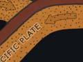
Going under: subduction and earthquakes
Where a plate with thin oceanic crust collides with a plate with continental crust, the plate with the oceanic crust is forced down under the continental plate and into the subsurface – a process called subduction. Friction, however, prevents the down-going plate from sliding under smoothly. As it descends, it drags against the overlying plate, and eventually the crust of the overlying plate fractures, shifts or crumples, causing frequent shallow earthquakes.
Much more rarely, a large area of the down-going oceanic plate overcomes friction and abruptly shoves its way further under the overlying plate. This can produce very powerful earthquakes, which scientists call subduction earthquakes. Some of the largest earthquakes in the world, with magnitudes greater than 9, have been subduction earthquakes
Subduction is responsible for earthquakes in many New Zealand regions. In the North Island, no subduction earthquakes have occurred during the period of European settlement. Sediment deposits from subduction earthquakes, including tsunami deposits, have been found in coastal areas in the North and northern South Island.
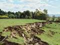
Ocean crust of the Pacific Plate is descending under the eastern North Island and Marlborough. Here the land has splintered into long blocks separated by major faults. Along these faults, the blocks have intermittently shifted both horizontally and vertically. Some have been tilted upward, forming mountains such as the Tararuas in the North Island and the Kaikōuras in the South Island. Movement on these long faults has produced several earthquakes of magnitude 7 or greater, such as the 1848 earthquakes along the Awatere Fault in Marlborough, the 1855 Wairarapa earthquake and the 1888 earthquake along the Hope Fault in North Canterbury. The 2016 Kaikōura magnitude 7.8 earthquake resulted from the progressive rupture of a series of shorter faults along the north-eastern coast of the South Island.
In the central North Island, the brittle crust of the overlying plate is being pulled apart, and parts of the region are subsiding. The 1987 Edgecumbe earthquake occurred in this area. Small earthquakes, related to volcanic activity rather than crustal stress, also occur in the central North Island volcanic zone.
Near the south-western end of the South Island, the roles of the plates are reversed. Here the Australian Plate has a thin crust of oceanic rock. Just offshore from Fiordland, it descends beneath the thicker continental crust of the South Island. The magnitude 7.8 Fiordland earthquake on 15 July 2009 was a subduction earthquake – the result of the oceanic rock under the Tasman Sea moving inward under the South Island.
Subduction also causes very deep earthquakes. These earthquakes occur within the sinking oceanic crust as the stiff slabs are bent downward. There are distinctive zones of deep earthquakes beneath the North Island and Marlborough, and under Fiordland.
Slow slip events
Sometimes slow slippage occurs along the subduction boundary over a period of days, weeks or months. These ‘silent earthquakes’ produce no seismic tremors and can be detected only by GPS measurements of movement of land above the subduction zone. They occur most frequently in the Gisborne, Hawke’s Bay, Manawatū and Kāpiti regions. The 2016 Kaikōura earthquake triggered slow slip movement in all of these areas.
Continent meets continent: the Alpine Fault
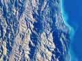
In the central South Island, the colliding Australian and Pacific plates are both thick continental crust, so one plate cannot sink under the other. Instead, the crust of the Pacific Plate is being buckled, broken and forced upward, creating the Southern Alps. The boundary between the plates is the huge Alpine Fault. Earthquakes along the Alpine Fault have often been very large – the last occurred in about 1717 CE, with movement along 375 kilometres of the fault. East of the Alpine Fault, earthquakes also occur on numerous smaller faults that criss-cross the region. There have been earthquakes in the magnitude 7 range near Arthur’s Pass and Murchison in 1929 and Īnangahua in 1968.