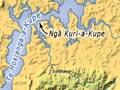
Hokianga Harbour
Extensive harbour on Northland’s wild west coast, reaching far inland. The green, craggy south head near the coastal village of Ōmāpere was once a signal station for shipping. The north head has towering, bleached sand dunes, some up to 170 m high.
Māori history
The harbour’s full name, Hokianga-nui-a-Kupe – the final departure place of Kupe (for Hawaiki) – recognises its association with the famous Polynesian explorer. Hokianga has a long Māori history, and a strong Ngāpuhi presence today.
European traders
The harbour was one of the first points of Māori–European contact. The occasional ship called from around 1800. Although a dangerous bar made the harbour entrance risky, a waterway navigable for some 24 km from the entrance drew European visitors in the 1820s. In ventures that combined Māori and European, the kauri forest was exploited in a thriving timber trade. There was shipbuilding at Hōreke in the late 1820s.
Missionaries
Missionaries followed traders. A Wesleyan mission was established in 1828 by John Hobbs at Mangungu – where the Treaty of Waitangi was signed by some 60 chiefs on 12 February 1840. In 1838 Jean Baptiste François Pompallier, New Zealand’s first Catholic missionary bishop, said the first Catholic mass not far from Motutī. In 2002 his bones were brought from France and buried at Motutī. Another Catholic settlement, Panguru, was the home of one of Northland’s most famous 20th-century elders, Whina Cooper.
Economic activity
Hokianga soon became a busy centre for the kauri and gum trades, and for flax milling. It was also a thriving port, as shipping was the only means of exporting the products. When the exploitative trade diminished around 1900, farming developed very slowly. Much of the land remained in Māori ownership. In the 1930s government-funded development of multiply-owned Māori land and improved roading and forestry work brought economic advances.
The French threat
Arriving at Hokianga with a group of colonists in 1837, eccentric Frenchman Charles Philippe Hippolyte de Thierry proclaimed himself ‘Sovereign Chief of New Zealand’. He was ridiculed and deserted by his followers, but both Māori and the English were worried about French colonising ambitions. Ngāpuhi chiefs provided land for him at Hokianga, on condition that he abandon his audacious scheme.
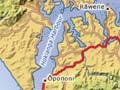
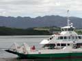
Rāwene
Township on a narrow peninsula in the middle of Hokianga Harbour, linked by car ferry to Kohukohu on the harbour’s northern shore. It had a 2013 population of 471.
At first it was a timber centre, and in the early 1800s a mill and shipyards were established. In 1826 there was an unsuccessful settlement organised by the first New Zealand Company.
Historic buildings include the last house of James Reddy Clendon, who was US consul at the Bay of Islands in the 1830s. He was a witness to the Treaty of Waitangi in 1840, a member of the first Legislative Council from 1841–44, and a magistrate from 1850.
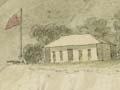
George McCall Smith, an archetypal backblocks doctor, developed Hokianga’s unique health service, centred on Rāwene Hospital, which he headed from 1914 to 1948. Hokianga was designated a special health area in 1941, and special provision for health services continues.
Opononi
Village on the harbour’s south shore near Ōmāpere. Opononi became world-famous in the summer of 1955–56 when a playful dolphin swam with children and gave them rides on her back. Named Opo, she was to have been given protection by law, but died in mysterious circumstances before this came into force. She was memorialised by writers and artists, and there is a sculpture at her grave.
Mangamuka
District at the junction of Ōpurehu and Mangamuka rivers, both of which feed the upper reaches of the Hokianga Harbour, 36 km south-east of Kaitāia. The Mangamuka Gorge is at the base of the Maungataniwha Range. The mountainous forested area contains giant kauri trees. The settlement of Mangamuka Bridge is at the point where State Highway 1 crosses the Mangamuka River.