South Island and Stewart Island
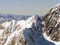
Large areas of the South Island, including much of the Southern Alps, consist of masses of drab grey sedimentary rocks known as greywacke. Their layers and the rare fossils they contain indicate they were once deposited on the sea floor, but most are now folded and broken into huge slabs that stand nearly on end, like books on a shelf. To the west and south, these grey rocks are transformed into schist, a rock with glittering minerals formed under high heat and pressure.
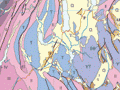
Cutting across the South Island is a straight boundary that is visible from space – the Alpine Fault. Immediately east of the fault, the greywacke and schist of the Southern Alps have been raised many thousands of metres. In the regions west of the fault, in north-west Nelson, Fiordland, and also on Stewart Island, the bedrock is quite different and includes much older rocks, as well as masses of granitic rock solidified from molten magma. Geologist Harold Wellman realised that large areas of rocks in north-west Nelson matched rocks in Fiordland and Otago. He proposed that these rocks were once continuous. A major section of the country has been wrenched apart and shunted over 480 kilometres along the Alpine Fault over the last 20 million years.
North Island
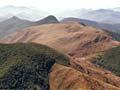
The greywackes that make up the Southern Alps also underlie large areas of the North Island, but they are exposed only in mountains such as the Tararua and Ruahine ranges. In the rest of the North Island, they are buried under blankets of more recently deposited sedimentary rocks. On the Coromandel Peninsula and in the north of the central North Island, the greywacke is masked by great thicknesses of volcanic rock.
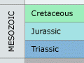
The geological time scale
Earth’s history can be deciphered from layers of rock and the remnants of life fossilised within them. Based on the changing succession of fossils, scientists have split geological time into major divisions called periods. Some period names, such as the Jurassic, are familiar to many people. The periods were originally based on sequences of rocks found in Europe. One period ends and another begins at the point when a sudden change can be seen in the rocks and fossils that were being deposited.
Fossils show the changes in the plants and animals that lived on the land and in the seas. Most fossils preserved in New Zealand are slightly different to those in Europe, but they show the same evolutionary changes and are similar enough to be useful guides.
In New Zealand the major international time periods have been subdivided into shorter spans of time – called series and stages – and given local names, generally after the places where the rocks formed during that time are best seen. New Zealand is unusual in having one of the thickest and most complete Cenozoic successions in the world.
How old are the rocks?
The age of rocks which have been crystallised from molten material (igneous rocks), or altered by heat and pressure (metamorphic rocks), can be determined by analysing the breakdown of radioactive minerals in them. By dating crystalline rocks of the land and the sea floor, and seeing how these relate to New Zealand’s sedimentary rock layers, scientists have worked out a basic outline of the country’s geological history. The oldest rocks in New Zealand formed about 510 million years ago, during the Cambrian period.