
The people who settled New Zealand came to a dramatic and unquiet land, with rugged mountains, active volcanoes and frequent earthquakes. It is a country with a complex geological history. Its bedrock is a geological jigsaw puzzle. An understanding of New Zealand’s past and its lively geological activity has come only in recent decades, as scientists have developed a theory of the global workings of the earth’s crust – a concept called plate tectonics.
A mobile planet
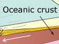
Earth’s main features – its continents and ocean floors – are not fixed. The earth’s surface is divided into about 15 major segments, or plates, that move slowly about on the soft, plastic rock of the underlying mantle. At mid-ocean ridges, molten material wells up to the surface and cools. This creates a new sea floor that slowly moves away from the ridges a few centimetres per year. Where two plates meet, old parts of the ocean floor sink back down. Embedded in the moving plates, the continents drift together or split apart, constantly changing the geography of the planet.
Highlands of a sunken continent
Exploration of the sea floor has revealed that the land we call New Zealand was once more extensive than it is today. The long, narrow, mountainous landmass of New Zealand is merely the highlands of a submerged continent called Zealandia. Extending to the north-west of the country are large, shallow continental shelf areas – the Challenger Plateau and Lord Howe Rise. To the south-east are the Chatham Rise and Campbell Plateau. Offshore drilling shows that the same rock type that makes up much of the Southern Alps underlies the continental shelves as well.
New Zealand – a collision zone
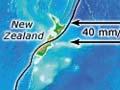
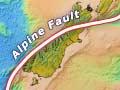
The mostly submerged New Zealand continent, Zealandia, sits uneasily astride two moving segments of the planet’s surface – the Pacific and Australian plates. In the North Island, the boundary between the plates lies off the East Coast along a depression, the Hikurangi Trough, at the edge of the continental shelf. In the Marlborough region, the boundary cuts diagonally across the South Island to the West Coast. It then continues south-westward along the great Alpine Fault, and runs back out to sea near Milford Sound.
The two moving plates are colliding at a glancing angle. In the process, the sunken New Zealand continent is crumpling to form the land that now projects above sea level. In the north, ocean floor at the surface of the Pacific Plate to the east plunges beneath the continental shelf off the eastern North Island. As it does so, it pushes up the overlying rocks and sediments, creating the hilly terrain of the eastern North Island. In the South Island, the two plates are directly colliding along the Alpine Fault. This causes a much greater uplift, forming the Southern Alps.
At the same time, the country is being wrenched apart. Along the Alpine Fault in the South Island, the West Coast region west of the plate boundary is moving north-east at 2–3 metres per century, relative to the Southern Alps on the eastern side. As this movement continues in the future, the South Island will become more elongated.