
Criticism of burning tussock grasslands: 19th century
Criticism of burning in the South Island began during the time when sheep and cattle farming was expanding. In 1865 John Buchanan wrote that repeated burning in dry districts of the South Island caused the pastures to deteriorate, reducing the number of sheep that runs could carry.
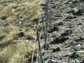
In 1895 the term ‘indiscriminate burning’ was coined. Critics claimed that runholders burned at all times of the year, and for no apparent reason. Some thought that depleting the vegetation allowed rabbits to invade the grasslands, which in turn reduced the vegetation even more. Others held that burning and overgrazing by sheep and rabbits increased erosion, causing widespread loss of soil and the formation of the scree slopes that are a feature of the high hills of Marlborough, Canterbury and Otago.
A. D. McIntosh, in his history of Marlborough, described the loss of vegetation and degradation of the land, resulting in masses of rock and shingle where once there were metres of soil.
Reassessing: 1980s onwards
There has been a reassessment of the burning practices of 19th-century South Island pastoralists.
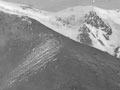
In the 1990s, geomorphologist Ian Whitehouse compared current photographs with those from the past, and found between the 1880s and the 1980s there had been little change in the distribution of bare, eroded areas. He argued that erosion had always been rapid in the high country and was linked more to high rainfall and steep slopes than the activities of farmers. Screes once thought to be caused by overgrazing and burning were, he claimed, now seen as older natural features. Comments in early sheep-station diaries indicate that burning tussock grasslands was often done with care.
Fire, earth and water
Burning Gisborne’s forest-clad hills for farming led to some of the worst erosion and flooding in New Zealand. In a storm on 19 February 1938, thousands of hectares slipped. Streams rose by 18 metres. One creek that normally flowed at 22 cusecs peaked at 33,900 cusecs. Twenty-one men lost their lives when a works camp near Māhia was washed away in a flash flood of the Kopuawhara River.
Burning and erosion in the North Island
When the easier and more accessible land had been taken up in the North Island in the early 20th century, farmers moved into the steeper hill country, where they continued to destroy the bush by fire and axe. Removing bush and fern from the hillsides increased runoff after heavy rainfall, resulting in more frequent and severe flooding. Pastures sown to replace deep-rooting native plants could not bind the land, and during rainstorms millions of tonnes of soil slipped down and filled up the riverbeds.
Controlling erosion
Concern over the degraded landscapes around the country led to the Soil Conservation and Rivers Control Act 1941. This provided for a network of catchment boards to control local flooding and erosion. In time, the boards placed greater limits on agricultural burning, so that by the 1960s it was strictly controlled.