Story: Ngāti Toarangatira

Tāhoramaurea, Motungārara and Kapiti islands, 1843

Tāhoramaurea, Motungārara and Kapiti islands, 1843

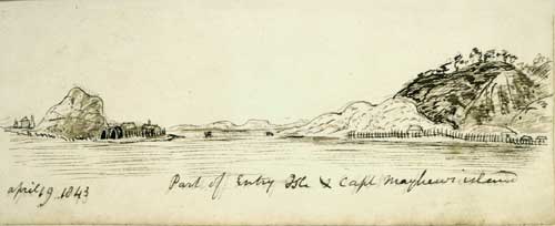
This sketch shows Tāhoramaurea Island (left) and Motungārara Island (right), with Kapiti Island in the right background and the South Island in the distance. The village of chief Te Rauparaha is on the right of Tāhoramaurea Island.

Using this item

Alexander Turnbull Library
Reference: E-296-q-043-4
Ink and watercolour sketch by Richard Taylor

Permission of the Alexander Turnbull Library, National Library of New Zealand, Te Puna Mātauranga o Aotearoa, must be obtained before any re-use of this image.

All images & media in this story

How to cite this page:

Mīria Pōmare, 'Ngāti Toarangatira - 19th century: rise and fall', Te Ara - the Encyclopedia of New Zealand, http://www.TeAra.govt.nz/en/artwork/1352/tahoramaurea-motungarara-and-kapiti-islands-1843 (accessed 28 March 2024)

Story by Mīria Pōmare, published 8 Feb 2005, updated 1 Mar 2017